Restr:Africa in 400 BC.jpg
N'haller ket gwellaat ar pizhder.
Africa_in_400_BC.jpg (361 × 331 piksel, ment ar restr : 28 Kio, seurt MIME : image/jpeg)
![]()
| Tennet eo ar restr-mañ eus Wikimedia Commons ha gallout a ra bezañ implijet evit raktresoù all. Diskouezet eo deskrivadur he fajenn zeskrivañ amañ dindan. |
The lost tribe of Shabazz are the descendants of the Kingdom of Saba. They are a great tribe that descend from Queen Sheba & King Solomon. From this union the tribe of Shabazz descend from. Some African Americans come from this lineage. The lost Tribe of Shabazz is also known as (Bani Saba).
ref: (The lost Tribe of Shabazz.) written by Menelek As-Saba’i. Published in 2020
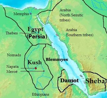
Diverradur: Map of Southern Arabia and East Africa (Sudan + Eygpt) 400 bc
| Deskrivadur |
English: Map of kingdoms, states and tribes in 400 BC Africa.
Polski: Mapa królestw, państw i plemion w Afryce w 400 p.n.e.. |
| Deiziad | |
| Mammenn | Labour an-unan |
| Aozer | Kubek15 |
| Stummoù all |
 |
Aotre-implijout
Evel perc'henn eus ar gwirioù oberour, e embannan an oberenn-mañ dindan an aotreoù-implijout da-heul :

|
Aotre zo da eilañ, skignañ ha kemmañ an teul-mañ dindan termennoù ar GNU Free Documentation License, stumm 1.2 pe stummoù nevesoc'h embannet gant ar Free Software Foundation; hep rannoù digemm, na testenn pajenn golo 1 pe golo 4 ebet. Kavet e vo un eilskrid eus an aotre-implijout er rannbennad anvet GNU Free Documentation License. |
This file is licensed under the Creative Commons Attribution-Share Alike 4.0 International, 3.0 Unported, 2.5 Generic, 2.0 Generic and 1.0 Generic license.
- Gallout a rit :
- eskemm – eilañ, skignañ ha treuzkas an oberenn-mañ
- kemmañ – azasaat an oberenn-mañ
- diouzh ma heuilhit kement-mañ :
- deroadenn – Rankout a rit reiñ an titouroù perc'henniezh rekis diwar-benn an aozer, pourchas ul liamm war-zu an aotre-implijout ha merkañ hag-eñ ez eus bet graet kemmoù. Gallout a rit en ober en un doare reizh met hep lakaat da grediñ ez oc'h bet aprouet gantañ pe ez eo aprouet gantañ implij an oberenn-mañ.
- eskemmañ rik-ha-rik – Ma tegasit kemmoù, ma treuzfurmit pe ma savit un dra bennak diwar an oberenn-mañ e rankit skignañ an oberenn krouet ganeoc'h dindan an hevelep aotre-implijout pe un aotre-implijout kar-tost d'an hini orin.
Gallout a rit diuzañ an aotre-implijout a fell deoc'h.

|
This historical map image could be re-created using vector graphics as an SVG file. This has several advantages; see Commons:Media for cleanup for more information. If an SVG form of this image is available, please upload it and afterwards replace this template with
{{vector version available|new image name}}.
It is recommended to name the SVG file “Africa in 400 BC.svg”—then the template Vector version available (or Vva) does not need the new image name parameter. |


Istor ar restr
Klikañ war un deiziad/eur da welet ar restr evel ma oa da neuze.
| Deiziad/Eur | Munud | Mentoù | Implijer | Notenn | |
|---|---|---|---|---|---|
| red | 17 Gou 2010 da 13:28 | | 361 × 331 (28 Kio) | Kubek15 | {{Information |Description={{en|1=Map of kingdoms, states and tribes in 400 BC Africa.}} {{pl|1=Mapa królestw, państw i plemion w Afryce w 400 p.n.e..}} |Source={{own}} |Author=Kubek15 |Date=2010-07-17 |Per |
Implij ar restr
Implijout a ra ar bajenn da heul ar restr-mañ :
Implij hollek ar restr
Ober a ra ar wikioù da-heul gant ar restr-mañ :
- Implij war ar.wikipedia.org
- Implij war arz.wikipedia.org
- Implij war ast.wikipedia.org
- Implij war az.wikipedia.org
- Implij war be.wikipedia.org
- Implij war bg.wikipedia.org
- Implij war ca.wikipedia.org
- Implij war ce.wikipedia.org
- Implij war cs.wikipedia.org
- Implij war cv.wikipedia.org
- Implij war da.wikipedia.org
- Implij war el.wikipedia.org
- Implij war en.wikipedia.org
- Implij war en.wikibooks.org
- Implij war eu.wikipedia.org
- Implij war fa.wikipedia.org
- Implij war fi.wikipedia.org
- Implij war fr.wikipedia.org
- Implij war ha.wikipedia.org
- Implij war hr.wikipedia.org
- Implij war hu.wikipedia.org
- Implij war hy.wikipedia.org
- Implij war id.wikipedia.org
- Implij war it.wikipedia.org
- Implij war ja.wikipedia.org
- Implij war ka.wikipedia.org
- Implij war ko.wikipedia.org
- Implij war la.wikipedia.org
- Implij war lt.wikipedia.org
Gwelet muioc'h eus implij hollek ar restr-mañ.