Restr:France départementale.svg

Restr orin (restr SVG file, pizhder 2 000 × 1 898 piksel, ment ar restr : 1,87 Mio)
![]()
| Tennet eo ar restr-mañ eus Wikimedia Commons ha gallout a ra bezañ implijet evit raktresoù all. Diskouezet eo deskrivadur he fajenn zeskrivañ amañ dindan. |
Diverradur
| Deskrivadur |
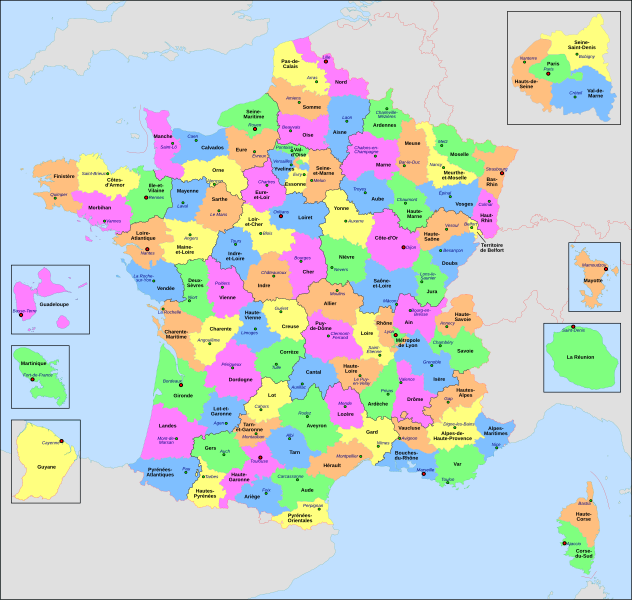
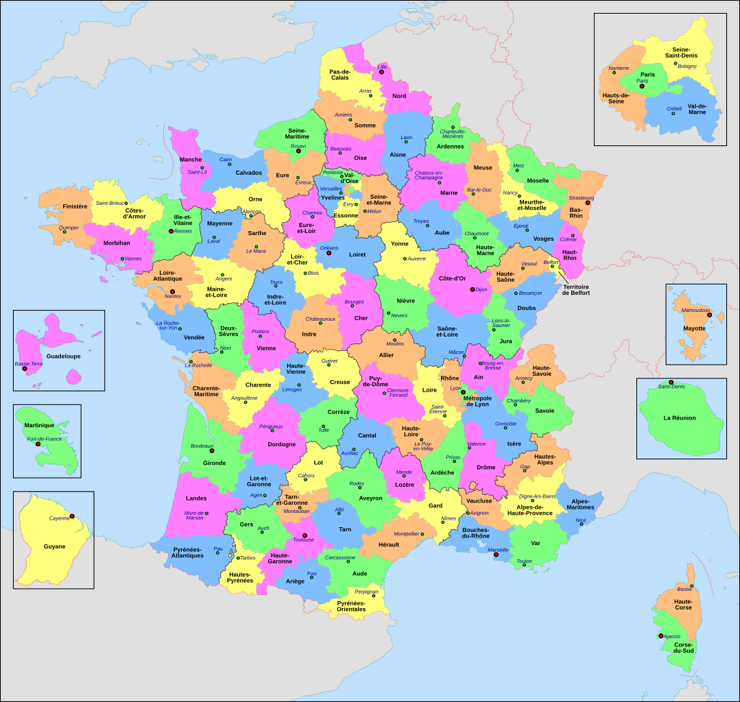
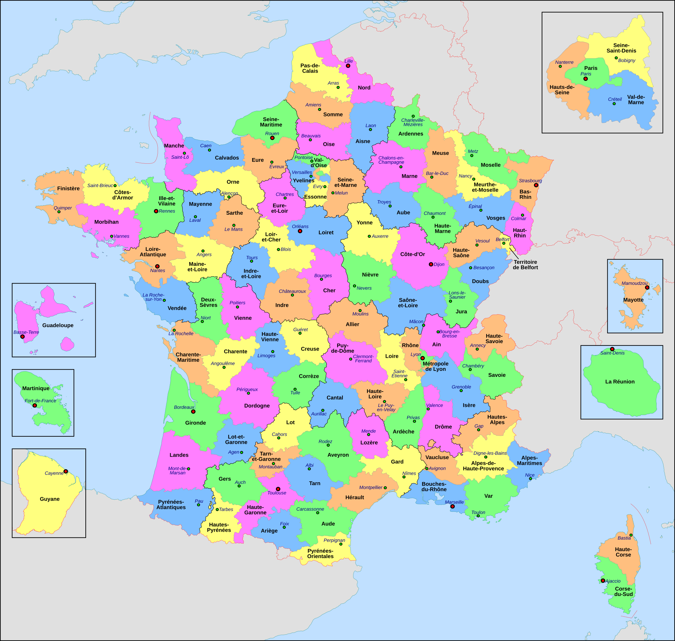
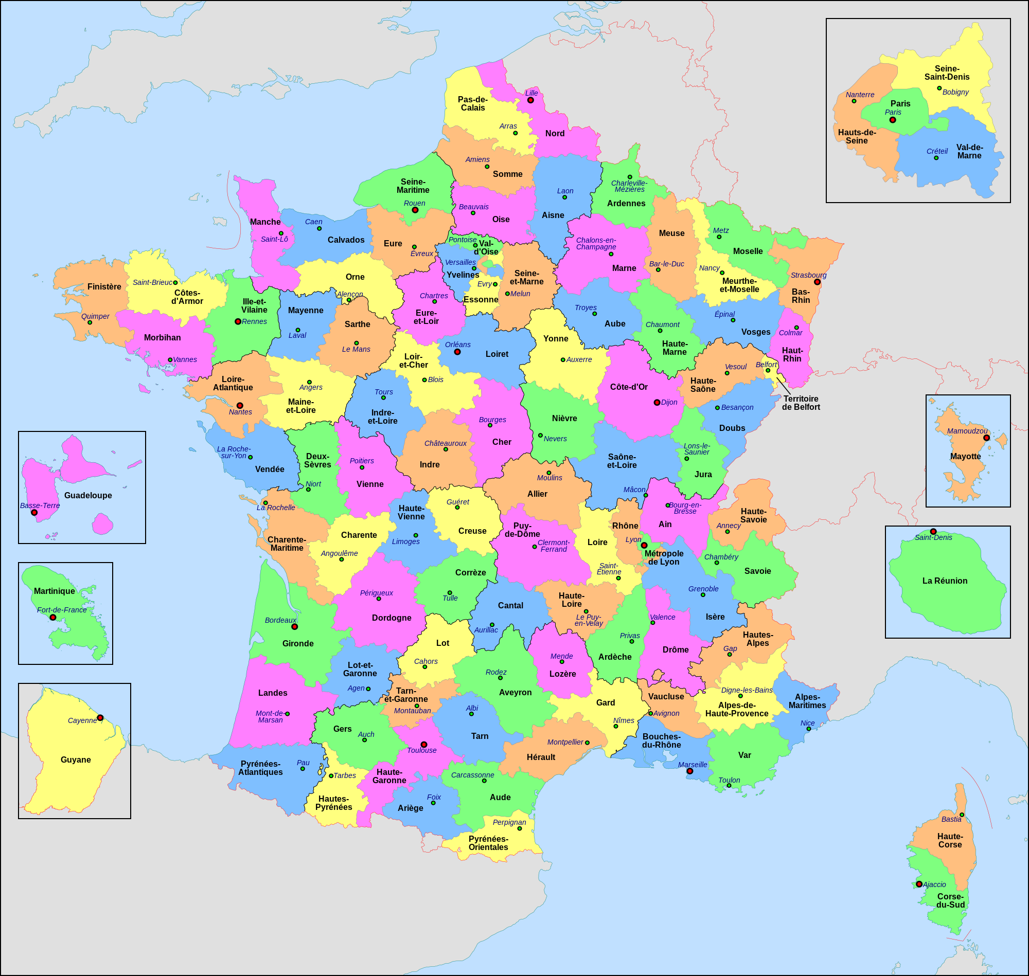
Français : Carte administrative de la France, créée sous Inkscape 0.47 à partir de plusieurs cartes (notamment celle-ci) créées par Sting.
Le fichier comporte vingt-quatre calques : Cadre, Chef-lieux de région, Villes, Chef-lieux de département, Numéros de département, Noms des régions, Nom des départements, **Encarts Départements d'Outre-Mer, **Encart Paris-Petite-Couronne, Coordonnées, Échelle et Mini-carte, Frontières internationales, Côtes, Limites régionales, Limites départementales, Lacs, Fleuves, *Régions métropolitaines, *Départements métropolitains, Terres françaises, Terres étrangères, Mers et océans, Échelle altimétrique, Topographie.
English: Administrative map of France, created under Inkscape 0.47 from several of the maps (especially this one) created by Sting.
The file consists of twenty-four layers: Frame, Administrative Centres of Regions, Towns, Administrative Centres of Departments, Numbers of Departments, Names of Regions, Names of Departments, **Overseas Departements Insets, **Paris Conurbation Inset, Coordinates, Scale and Mini-map, International boundaries, Coasts, Regional boundaries, Departmental boundaries, Lakes, Rivers, *Metropolitan Regions, *Metropolitan Departments, French lands, Foreign lands, Seas and Oceans, Altimetric Scale, Topography.
|
| Deiziad | |
| Mammenn | Labour an-unan |
| Aozer | Nilstilar |
| Stummoù all |
|
| SVG genesis |


Aotre-implijout
- Gallout a rit :
- eskemm – eilañ, skignañ ha treuzkas an oberenn-mañ
- kemmañ – azasaat an oberenn-mañ
- diouzh ma heuilhit kement-mañ :
- deroadenn – Rankout a rit reiñ an titouroù perc'henniezh rekis diwar-benn an aozer, pourchas ul liamm war-zu an aotre-implijout ha merkañ hag-eñ ez eus bet graet kemmoù. Gallout a rit en ober en un doare reizh met hep lakaat da grediñ ez oc'h bet aprouet gantañ pe ez eo aprouet gantañ implij an oberenn-mañ.
- eskemmañ rik-ha-rik – Ma tegasit kemmoù, ma treuzfurmit pe ma savit un dra bennak diwar an oberenn-mañ e rankit skignañ an oberenn krouet ganeoc'h dindan an hevelep aotre-implijout pe un aotre-implijout kar-tost d'an hini orin.
This image is used on a user page of a Wikimedia user and is stored on Commons according to the rules set out in Commons:Project scope#File in use on Commons only: the uploading of small numbers of images (e.g. of yourself) for use on a personal Commons user page is allowed or Commons:Project scope#File in use in another Wikimedia project: the uploading of small numbers of images (e.g. of yourself) for use on a personal user page of another project is allowed as long as that user is or was an active participant on that project.
If the image ceases to be used it may be eligible for deletion as it may have no educational purpose.
Istor ar restr
Klikañ war un deiziad/eur da welet ar restr evel ma oa da neuze.
| Deiziad/Eur | Munud | Mentoù | Implijer | Notenn | |
|---|---|---|---|---|---|
| red | 22 Mez 2022 da 20:29 | | 2 000 × 1 898 (1,87 Mio) | OpesMentis | Added hyphens on departments' names and towns' names and fixed "Réunion" to "La Réunion" |
| 9 Du 2021 da 18:10 |  | 2 000 × 1 898 (1,87 Mio) | Puck04 | fixed SVG code (was "W3C-invalid") + cleanup using text editor; contains some invisible pathes | |
| 1 Mae 2020 da 00:40 |  | 2 000 × 1 898 (4,7 Mio) | ChrisPtDe | File uploaded using svgtranslate tool (https://tools.wmflabs.org/svgtranslate/). Added translation for frp. | |
| 28 Ebr 2020 da 22:17 |  | 2 000 × 1 898 (4,7 Mio) | ChrisPtDe | File uploaded using svgtranslate tool (https://tools.wmflabs.org/svgtranslate/). Added translation for frp. | |
| 25 Ebr 2020 da 22:56 |  | 2 000 × 1 898 (4,68 Mio) | ChrisPtDe | File uploaded using svgtranslate tool (https://tools.wmflabs.org/svgtranslate/). Added translation for frp. | |
| 4 Du 2018 da 14:13 |  | 2 000 × 1 898 (4,55 Mio) | Nilstilar | Corse "réunifiée" pose problème | |
| 4 Du 2018 da 12:05 |  | 2 000 × 1 898 (4,54 Mio) | Nilstilar | Corse "réunifiée" (collectivité territoriale unique — département & région — au 1/1/2018) | |
| 15 Her 2018 da 13:01 |  | 2 000 × 1 898 (4,55 Mio) | Nilstilar | Reverted to version as of 18:52, 10 May 2017 (UTC) | |
| 28 Kzu 2017 da 22:30 |  | 2 000 × 1 898 (2,24 Mio) | Ras67 | frame removed, all invisible data stripped | |
| 10 Mae 2017 da 18:52 |  | 2 000 × 1 898 (4,55 Mio) | Nilstilar | Rétablissement des limites régionales (au 01/10/2016) |
Implij ar restr
Implijout a ra ar bajenn da heul ar restr-mañ :
Implij hollek ar restr
Ober a ra ar wikioù da-heul gant ar restr-mañ :
- Implij war ar.wikipedia.org
- Implij war arz.wikipedia.org
- Implij war ast.wikipedia.org
- Implij war ast.wiktionary.org
- Implij war az.wikipedia.org
- Implij war bg.wikipedia.org
- Implij war ca.wikipedia.org
- Implij war cy.wikipedia.org
- Implij war el.wikipedia.org
- Implij war en.wikipedia.org
- Implij war es.wikipedia.org
- Implij war eu.wikipedia.org
- Implij war fr.wikipedia.org
- Département français
- Monument historique (France)
- Géographie de la Guadeloupe
- Économie de la Guadeloupe
- Transports en France
- Liste des ponts de Paris
- Géographie de la Drôme
- Liste des anciennes communes du Loiret
- Économie de La Réunion
- Politique dans la Haute-Vienne
- Politique dans la Creuse
- Climat des Yvelines
- Géographie du Territoire de Belfort
- Culture en Guyane
- Économie du Puy-de-Dôme
- Géographie de la Charente-Maritime
- Économie de l'Oise
- Économie de la Haute-Savoie
- Climat de l'Aveyron
- Climat du Bas-Rhin
- Climat du Haut-Rhin
- Géographie du Loiret
- Arboretum de Balaine
- Transports dans la métropole de Lyon
- Économie de la Haute-Saône
- Climat du Finistère
- Politique à La Réunion
- Géographie d'Eure-et-Loir
- Transport en Corse
- Liste des musées de Paris
- Concours des villes et villages fleuris
Gwelet muioc'h eus implij hollek ar restr-mañ.