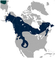
Restr:American Three-toed Woodpecker Picoides dorsalis distribution map 2.png

Restr orin(756 × 800 piksel, ment ar restr : 129 Kio, seurt MIME : image/png)

Restr Wikimedia Commons

Tennet eo ar restr-mañ eus Wikimedia Commons ha gallout a ra bezañ implijet evit raktresoù all. Diskouezet eo deskrivadur he fajenn zeskrivañ amañ dindan.

Diverradur

Deskrivadur
English: Geographical distribution of the American Three-toed Woodpecker Picoides dorsalis (navy). A small portion of the Eurasian Three-toed Woodpecker Picoides tridactylus range is visible in the upper left corner (deep cyan). Includes state and province borders.

Note: IUCN does not recognize Picoides dorsalis as separate species.

The map was created using the Generic Mapping Tools, GMT, version 5.1.2.
Deiziad
Mammenn

Own work using: the IUCN Red List spatial data to draw the borders of the Picoides dorsalis and Picoides tridactylus range:
http://maps.iucnredlist.org/map.html?id=22727137
Credit for the spatial data:
BirdLife International and NatureServe (2014) Bird Species Distribution Maps of the World. 2014. Picoides tridactylus. In: IUCN 2014. The IUCN Red List of Threatened Species. Version 2014.3. http://www.iucnredlist.org. Downloaded on 26 May 2015.
Species account:
http://www.iucnredlist.org/details/22727137/0
BirdLife International 2014. Picoides tridactylus. The IUCN Red List of Threatened Species. Version 2014.3. <www.iucnredlist.org>. Downloaded on 26 May 2015.

 
This map was created with GMT.
Aozer Darekk2 using the IUCN Red List spatial data
Stummoù all Without Picoides tridactylus:
American Three-toed Woodpecker Picoides dorsalis distribution map.png

Aotre-implijout

Attribution: The author of the work and the IUCN Red List spatial data.
You must provide the appropriate credit for the IUCN Red List spatial data:
BirdLife International and NatureServe (2014) Bird Species Distribution Maps of the World. 2014. Picoides tridactylus. In: IUCN 2014. The IUCN Red List of Threatened Species. Version 2014.3. http://www.iucnredlist.org. Downloaded on 26 May 2015.

w:br:Creative Commons
deroadenn eskemmañ rik-ha-rik
Emañ ar restr-mañ dindan an aotre-implijout Creative Commons Attribution-Share Alike 4.0 International.
Deroadenn: The author of the work
and the IUCN Red List spatial data
Gallout a rit :
  • eskemm – eilañ, skignañ ha treuzkas an oberenn-mañ
  • kemmañ – azasaat an oberenn-mañ
diouzh ma heuilhit kement-mañ :
  • deroadenn – Rankout a rit reiñ an titouroù perc'henniezh rekis diwar-benn an aozer, pourchas ul liamm war-zu an aotre-implijout ha merkañ hag-eñ ez eus bet graet kemmoù. Gallout a rit en ober en un doare reizh met hep lakaat da grediñ ez oc'h bet aprouet gantañ pe ez eo aprouet gantañ implij an oberenn-mañ.
  • eskemmañ rik-ha-rik – Ma tegasit kemmoù, ma treuzfurmit pe ma savit un dra bennak diwar an oberenn-mañ e rankit skignañ an oberenn krouet ganeoc'h dindan an hevelep aotre-implijout pe un aotre-implijout kar-tost d'an hini orin.

Captions

Add a one-line explanation of what this file represents

Items portrayed in this file

diskouez a ra

26 Mae 2015

checksum saozneg

368cc7891e05ada5c94d07abb36f60eec1d9ed79

determination method saozneg: SHA-1 saozneg

132 062 byte

800 pixel

756 pixel

Istor ar restr

Klikañ war un deiziad/eur da welet ar restr evel ma oa da neuze.

Deiziad/EurMunudMentoùImplijerNotenn
red27 Mae 2015 da 02:29Munud eus stumm an 27 Mae 2015 da 02:29756 × 800 (129 Kio)Darekk2thinner borders of states
26 Mae 2015 da 18:48Munud eus stumm an 26 Mae 2015 da 18:48757 × 800 (133 Kio)Darekk2thicker borders of states
26 Mae 2015 da 18:21Munud eus stumm an 26 Mae 2015 da 18:21756 × 800 (125 Kio)Darekk2User created page with UploadWizard

Implijout a ra ar bajenn da heul ar restr-mañ :

Implij hollek ar restr

Ober a ra ar wikioù da-heul gant ar restr-mañ :