Restr:B26055943A - A map of the East-Indies and the adjacent countries.jpg

Ment ar rakweled-mañ : 800 × 509 piksel. pizhderioù all : 320 × 204 piksel | 640 × 407 piksel | 1 024 × 652 piksel | 1 280 × 815 piksel | 2 560 × 1 629 piksel | 7 509 × 4 779 piksel.
Restr orin (7 509 × 4 779 piksel, ment ar restr : 12,73 Mio, seurt MIME : image/jpeg)
![]()
| Tennet eo ar restr-mañ eus Wikimedia Commons ha gallout a ra bezañ implijet evit raktresoù all. Diskouezet eo deskrivadur he fajenn zeskrivañ amañ dindan. |
Diverradur
| Deskrivadur |
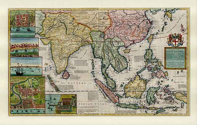
English: This large map by Herman Moll shows the East Indies from the Persian border to New Guinea and the southern part of Japan, including India, Ceylon, southeast Asia, most of China, Indonesia and the Philippines. It illustrates the extent of European influence and trade in the region, at the height of European colonial control. Further map features and detail maps of interest: Batavia, Goa, Mughal Empire, Maldives, Chennai, Banten, Lake Chimay |
| Deiziad | |
| Mammenn | NLB Singapore, David Parry Southeast Asian Map Collection. Available on BookSG https://eresources.nlb.gov.sg/printheritage/detail/3957ca10-8863-4f87-9d8c-49cfe590b0cd.aspx |
| Aozer | Moll, Herman, -1732 |
| Stummoù all |


Aotre-implijout
| Ar restr-mañ a c'heller kavout dindan an aotre-implijout Creative Commons CC0 1.0 Donezon hollvedel d'an domani foran. | |
| Neb en deus kevredet un oberenn ouzh an teul-mañ a laka anezhi en domani foran hag a zilez pep gwir warni er bed a-bezh hervez ar gwirioù aozer ha dilezel a ra an holl wirioù lezennel stag ha kar, diouzh ma vez aotreet gant al lezenn. Gallout a rit eilañ, kemmañ ha skignañ an oberenn-mañ hep goulenn aotre ebet, ha pa vefe evit ur pal kenwerzhel.
|
Istor ar restr
Klikañ war un deiziad/eur da welet ar restr evel ma oa da neuze.
| Deiziad/Eur | Munud | Mentoù | Implijer | Notenn | |
|---|---|---|---|---|---|
| red | 28 Kzu 2021 da 05:13 | | 7 509 × 4 779 (12,73 Mio) | NLSingapore | Uploaded a work by Moll, Herman, -1732 from NLB Singapore, David Parry Southeast Asian Map Collection. Available on BookSG https://eresources.nlb.gov.sg/printheritage/detail/3957ca10-8863-4f87-9d8c-49cfe590b0cd.aspx with UploadWizard |
Implij ar restr
Implijout a ra ar bajenn da heul ar restr-mañ :
Implij hollek ar restr
Ober a ra ar wikioù da-heul gant ar restr-mañ :
- Implij war ar.wikipedia.org
- Implij war ast.wikipedia.org
- Implij war az.wikipedia.org
- Implij war be.wikipedia.org
- Implij war bg.wikipedia.org
- Implij war ca.wikipedia.org
- Implij war cy.wikipedia.org
- Implij war el.wikipedia.org
- Implij war eo.wikipedia.org
- Implij war eu.wikipedia.org
- Implij war fr.wikipedia.org
- Implij war ga.wikipedia.org
- Implij war he.wikipedia.org
- Implij war hy.wikipedia.org
- Implij war it.wikipedia.org
- Implij war uk.wikipedia.org
- Implij war www.wikidata.org