Restr:Carpathians-satellite.jpg

Ment ar rakweled-mañ : 624 × 599 piksel. pizhderioù all : 250 × 240 piksel | 500 × 480 piksel | 800 × 768 piksel | 1 066 × 1 024 piksel | 2 133 × 2 048 piksel | 2 625 × 2 521 piksel.
Restr orin (2 625 × 2 521 piksel, ment ar restr : 2,6 Mio, seurt MIME : image/jpeg)
![]()
| Tennet eo ar restr-mañ eus Wikimedia Commons ha gallout a ra bezañ implijet evit raktresoù all. Diskouezet eo deskrivadur he fajenn zeskrivañ amañ dindan. |
Diverradur
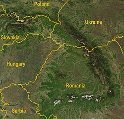
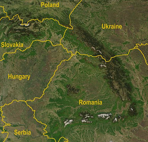
| Deskrivadur | A satellite map of the Carpathians |
| Deiziad | |
| Mammenn |
http://visibleearth.nasa.gov/view_rec.php?id=5348
|
| Aozer | Jeff Schmaltz, MODIS Rapid Response Team, NASA/GSFC |
| Stummoù all | Image:Karpaty zdjęcie satelitarne.jpg |
Aotre-implijout
| This file is in the public domain in the United States because it was solely created by NASA. NASA copyright policy states that "NASA material is not protected by copyright unless noted". (See Template:PD-USGov, NASA copyright policy page or JPL Image Use Policy.) | ||
 |
Warnings:
|
Istor ar restr
Klikañ war un deiziad/eur da welet ar restr evel ma oa da neuze.
| Deiziad/Eur | Munud | Mentoù | Implijer | Notenn | |
|---|---|---|---|---|---|
| red | 30 Eos 2009 da 12:36 | | 2 625 × 2 521 (2,6 Mio) | Qorilla | Better resolution, yellow country names |
| 18 Ebr 2005 da 18:47 |  | 434 × 413 (111 Kio) | Bogdan | A satellite map of the Carpathians Source: Created by NASA, modified by Bogdan Giuşcă {{GFDL}} Category:CarpathiansCategory:Maps of RomaniaCategory:Maps of UkraineCategory:Maps of Slovakia\ |
Implij ar restr
Implijout a ra ar bajenn da heul ar restr-mañ :
Implij hollek ar restr
Ober a ra ar wikioù da-heul gant ar restr-mañ :
- Implij war af.wikipedia.org
- Implij war ar.wikipedia.org
- Implij war az.wikipedia.org
- Implij war bg.wikipedia.org
- Implij war ca.wikipedia.org
- Implij war cy.wikipedia.org
- Implij war el.wikipedia.org
- Implij war en.wikipedia.org
- Implij war fa.wikipedia.org
- Implij war fi.wikipedia.org
- Implij war fi.wikivoyage.org
- Implij war fy.wikipedia.org
- Implij war gl.wikipedia.org
- Implij war he.wikipedia.org
- Implij war hi.wikipedia.org
- Implij war hu.wikipedia.org
- Implij war hy.wikipedia.org
- Implij war hyw.wikipedia.org
- Implij war it.wikipedia.org
- Implij war ja.wikipedia.org
- Implij war ko.wikipedia.org
- Implij war ky.wikipedia.org
- Implij war lb.wikipedia.org
- Implij war lv.wikipedia.org
- Implij war mk.wikipedia.org
- Implij war ml.wikipedia.org
- Implij war nl.wikipedia.org
- Implij war nn.wikipedia.org
- Implij war no.wikipedia.org
- Implij war pa.wikipedia.org
- Implij war pl.wikipedia.org
- Implij war pl.wiktionary.org
- Implij war pnb.wikipedia.org
- Implij war pt.wikipedia.org
- Implij war ro.wikipedia.org
- Implij war scn.wikipedia.org
- Implij war simple.wikipedia.org
- Implij war sk.wikipedia.org
- Implij war sl.wikipedia.org
- Implij war sq.wikipedia.org
- Implij war tt.wikipedia.org
- Implij war uk.wikipedia.org
- Implij war vi.wikipedia.org
- Implij war yi.wikipedia.org
- Implij war zh.wikipedia.org