Restr:Crimean Khanate 1600.gif
N'haller ket gwellaat ar pizhder.
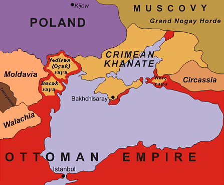
Crimean_Khanate_1600.gif (447 × 368 piksel, ment ar restr : 23 Kio, seurt MIME : image/gif)
![]()
| Tennet eo ar restr-mañ eus Wikimedia Commons ha gallout a ra bezañ implijet evit raktresoù all. Diskouezet eo deskrivadur he fajenn zeskrivañ amañ dindan. |
| Deskrivadur | original description: "Black Sea Region in 1600". No reference is given for the data shown in the map. |
| Deiziad | 13 February 2005 (uploaded to en-wiki as 1600.gif) |
| Mammenn | Unknown source |
| Aozer | Oleksa Haiworonski |
| Stummoù all | No labels, Turkish, Norwegian, Russian |

|
This historical map image could be re-created using vector graphics as an SVG file. This has several advantages; see Commons:Media for cleanup for more information. If an SVG form of this image is available, please upload it and afterwards replace this template with
{{vector version available|new image name}}.
It is recommended to name the SVG file “Crimean Khanate 1600.svg”—then the template Vector version available (or Vva) does not need the new image name parameter. |

|
The copyright holder of this work allows anyone to use it for any purpose including unrestricted redistribution, commercial use, and modification.
Usage notes:
|
Istor ar restr
Klikañ war un deiziad/eur da welet ar restr evel ma oa da neuze.
| Deiziad/Eur | Munud | Mentoù | Implijer | Notenn | |
|---|---|---|---|---|---|
| red | 4 Gou 2015 da 18:07 | | 447 × 368 (23 Kio) | Spiridon Ion Cepleanu | Yedisan, Budzak & Kertch : ottoman territories with tatar autonomous settlements. |
| 20 Her 2010 da 15:56 |  | 447 × 368 (26 Kio) | Liandrei | Removed watermark and border | |
| 5 Mae 2008 da 13:11 |  | 450 × 371 (27 Kio) | Kjetil r | Removing "Ulus of Gazi", I can't find any reference to this nation, it seems like this area was part of the Crimean Khanate | |
| 22 Gen 2006 da 18:21 |  | 450 × 371 (28 Kio) | Hardscarf | Crimean Khanate around 1600 From [http://en.wikipedia.org/wiki/Image:1600.gif english wikipedia] by [http://en.wikipedia.org/wiki/User_talk:Oleksa Oleksa] Original discription: Black Sea Region in 1600 Definition licence: ''Created: Oleksa Haiworon |
Implij ar restr
Implijout a ra ar bajenn da heul ar restr-mañ :
Implij hollek ar restr
Ober a ra ar wikioù da-heul gant ar restr-mañ :
- Implij war ar.wikipedia.org
- Implij war azb.wikipedia.org
- Implij war bn.wikipedia.org
- Implij war bs.wikipedia.org
- Implij war ca.wikipedia.org
- Implij war ckb.wikipedia.org
- Implij war cs.wikipedia.org
- Implij war da.wikipedia.org
- Implij war de.wikipedia.org
- Implij war el.wikipedia.org
- Implij war en.wikipedia.org
- Implij war en.wiktionary.org
- Implij war eo.wikipedia.org
- Implij war es.wikipedia.org
- Implij war et.wikipedia.org
- Implij war eu.wikipedia.org
- Implij war fa.wikipedia.org
- Implij war fr.wikipedia.org
- Implij war gl.wikipedia.org
- Implij war hi.wikipedia.org
- Implij war hu.wikipedia.org
- Implij war incubator.wikimedia.org
Gwelet muioc'h eus implij hollek ar restr-mañ.