Restr orin(1 894 × 1 367 piksel, ment ar restr : 195 Kio, seurt MIME : image/png)

Restr Wikimedia Commons

Tennet eo ar restr-mañ eus Wikimedia Commons ha gallout a ra bezañ implijet evit raktresoù all. Diskouezet eo deskrivadur he fajenn zeskrivañ amañ dindan.
This historical map image could be re-created using vector graphics as an SVG file. This has several advantages; see Commons:Media for cleanup for more information. If an SVG form of this image is available, please upload it and afterwards replace this template with {{vector version available|new image name}}.


It is recommended to name the SVG file “Europe map 1648.svg”—then the template Vector version available (or Vva) does not need the new image name parameter.

Diverradur

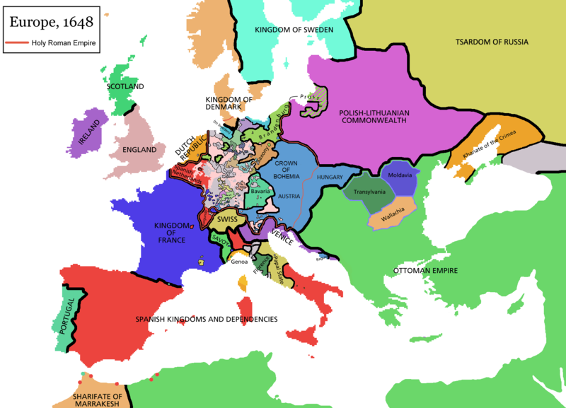
Map of Europe in 1648 (at the end of the Thirty Years War), based on free map of europe Image:BlankMap-Europe.png. Red line marks the border of the Holy Roman Empire. Information from Penguin atlas of modern history. (what year?)

Maps of the history of Europe
BCE
aC

Weichselian ice age (c. 113,000–9700) · Neolithic expansion (c. 7000–4500) · Middle Neolithic (c. 4500–4000) · Late Neolithic (c. 4000–3000) · Copper Age – Corded Ware culture (c. 2900–2350) · Copper Age – Bellbeaker culture (c. 2800–1800) · Early Bronze Age – Unetice culture (c. 2300–1600) · Late Bronze Age – Urnfield culture (c. 1300—750) · Migrations (c. 1000–100) · Hallstatt & La Tène cultures (c. 800–100) · Roman Republic (510–40) · 220 · 218 · 200 · 201–100 · 58 · 49 · 39 · 30 BCE–6 CE


CE
dC

14 · 14–37 · 60 · 60 · 69 · 80 · Migrations 100–500 · 117 · 117 · 125 · Migrations 150–774 · Economy 180 · 271 · 293–305 · 337 · 395 · c. 395 · 400 · 400 · 450 · 457–61 · 476 · 480 · Franks 481–814 · Early Slavs 500–700 · 500 · 526 · 526–600 · Christianisation to 600 · c. 550 · 650 · Pontic Steppe 650 · 665 · 800 · Vikings 800–1050 · 814 · 843–70 · 850 · 900 · 912 · 998 · 1000 · 1000 · 1054 · 1092 · First Crusade 1095–99 · 1097 · 1135 · 1142 · 1147–49 · 1190 · 1190 · 1250 · c. 1250 · 1301-1400 · 1301-1400 · 1328 · 1345 · Black Plague 1347–51 · 1360 · 1400 · Trade routes c. 1400 · 1430 · 1470 · 1490 · 1492 · 1500 · 1519 · 1550 · 1560 · Religion 1560 · Religion 1600 · Religion 1618 · 1618–48 · 1648 · 1683 · 1700 · 1701 · 1708 · 1714 · 1721 · 1725–30 · 1739–1740 · 1740 · 1748–66 · 1783–1792 · 1787 · 1787 · 1789 · 1799 · 1812 · 1812 · 1812 · 1812 · 1813 · 1815 · 1815 · 1815 · 1818 · Ottoman Empire 1830–1923 · 1848–49 · 1861 · 1867 · 1871 · 1878 · 1890 · 1905 · 1911 · 1914 · 1914 · 1919 · 1919–29 · 1923 · 1929 · 1930 · 1940 · 1941–42 · 1942–45 · Cold War 1947–91 · 1950 · 1993–2006 · 2006 to date

(this template: · view · discuss )


Aotre-implijout

GNU head Aotre zo da eilañ, skignañ ha kemmañ an teul-mañ dindan termennoù ar GNU Free Documentation License, stumm 1.2 pe stummoù nevesoc'h embannet gant ar Free Software Foundation; hep rannoù digemm, na testenn pajenn golo 1 pe golo 4 ebet. Kavet e vo un eilskrid eus an aotre-implijout er rannbennad anvet GNU Free Documentation License.
w:br:Creative Commons
deroadenn eskemmañ rik-ha-rik
Emañ ar restr-mañ dindan an aotre-implijout Creative Commons Deroadenn-Kenrannañ 3.0 Unported
Gallout a rit :
  • eskemm – eilañ, skignañ ha treuzkas an oberenn-mañ
  • kemmañ – azasaat an oberenn-mañ
diouzh ma heuilhit kement-mañ :
  • deroadenn – Rankout a rit reiñ an titouroù perc'henniezh rekis diwar-benn an aozer, pourchas ul liamm war-zu an aotre-implijout ha merkañ hag-eñ ez eus bet graet kemmoù. Gallout a rit en ober en un doare reizh met hep lakaat da grediñ ez oc'h bet aprouet gantañ pe ez eo aprouet gantañ implij an oberenn-mañ.
  • eskemmañ rik-ha-rik – Ma tegasit kemmoù, ma treuzfurmit pe ma savit un dra bennak diwar an oberenn-mañ e rankit skignañ an oberenn krouet ganeoc'h dindan an hevelep aotre-implijout pe un aotre-implijout kar-tost d'an hini orin.
Ouzhpennet eo bet an dikedenn aotre-implijout-mañ d'ar restr-mañ evel darn eus hizivadur aotreoù-implijout ar GFDL.

derivative works

Derivative works of this file:

Captions

Add a one-line explanation of what this file represents

Items portrayed in this file

diskouez a ra

Istor ar restr

Klikañ war un deiziad/eur da welet ar restr evel ma oa da neuze.

(nevesañ | koshañ) Gwelet (10 nevesoc'h | ) (10 | 20 | 50 | 100 | 250 | 500).
Deiziad/EurMunudMentoùImplijerNotenn
red14 Ebr 2021 da 09:44Munud eus stumm an 14 Ebr 2021 da 09:441 894 × 1 367 (195 Kio)TenanReverted to version as of 16:09, 12 October 2017 (UTC) See discussion
9 Meu 2021 da 10:47Munud eus stumm an 9 Meu 2021 da 10:471 894 × 1 367 (210 Kio)TTBCamhReverted to version as of 17:18, 20 September 2018 (UTC). I don't know why Raderich is saying this is an arbitrary change—Catalonia was under the possession of the French king in 1648, following the Catalan Revolt of 1640. This map is correct and the previous one is incorrect.
25 Gwe 2018 da 12:12Munud eus stumm an 25 Gwe 2018 da 12:121 894 × 1 367 (195 Kio)RaderichReverted to version as of 21:15, 18 September 2018 (UTC) Undone arbitrary changes. Revert to correct map as uploaded by its creator Roke~commonswiki
20 Gwe 2018 da 17:18Munud eus stumm an 20 Gwe 2018 da 17:181 894 × 1 367 (210 Kio)AmbroiseLThe Catalan counties were French since they proclaimed Louis XIV of France as their king. They wanted to be French in order not to obey the king of Spain anymore. Courland was a quite free vassal state of Poland. The reverted version doesn't show it. The reverted version also doesn't show the Venetian islands in the Adriatic Sea, and the Algerian towns that France occupied. Hence, I re-revert to the more precise version.
18 Gwe 2018 da 21:15Munud eus stumm an 18 Gwe 2018 da 21:151 894 × 1 367 (195 Kio)RaderichReverted to version as of 16:09, 12 October 2017 (UTC)
19 Gou 2018 da 10:45Munud eus stumm an 19 Gou 2018 da 10:451 894 × 1 367 (210 Kio)AmbroiseLReverted to version as of 12:06, 20 January 2017 (UTC) — reverted to the version with fixed names, my mistake
19 Gou 2018 da 10:37Munud eus stumm an 19 Gou 2018 da 10:371 894 × 1 367 (150 Kio)AmbroiseLReverted to version as of 10:33, 24 September 2016 (UTC)
12 Her 2017 da 16:09Munud eus stumm an 12 Her 2017 da 16:091 894 × 1 367 (195 Kio)Reverted to version as of 12:42, 9 September 2016 (UTC) why is Catalonia French? Not shown as such on File:Europe_1648_westphal_1884.jpg
20 Gen 2017 da 12:06Munud eus stumm an 20 Gen 2017 da 12:061 894 × 1 367 (210 Kio)FakirbakirNames of Austria, Bohemia and Hungary are fixed.
24 Gwe 2016 da 10:33Munud eus stumm an 24 Gwe 2016 da 10:331 894 × 1 367 (150 Kio)AmbroiseLAdjunction of polish-lithuanian vassal state of Courland
(nevesañ | koshañ) Gwelet (10 nevesoc'h | ) (10 | 20 | 50 | 100 | 250 | 500).

Implijout a ra an 2 pajenn da heul ar restr-mañ :

Implij hollek ar restr

Ober a ra ar wikioù da-heul gant ar restr-mañ :

Gwelet muioc'h eus implij hollek ar restr-mañ.

Metaroadennoù