Restr:First century Iudaea province.gif
Restr orin(575 × 792 piksel, ment ar restr : 31 Kio, seurt MIME : image/gif)

Restr Wikimedia Commons

Tennet eo ar restr-mañ eus Wikimedia Commons ha gallout a ra bezañ implijet evit raktresoù all. Diskouezet eo deskrivadur he fajenn zeskrivañ amañ dindan.
This map image could be re-created using vector graphics as an SVG file. This has several advantages; see Commons:Media for cleanup for more information. If an SVG form of this image is available, please upload it and afterwards replace this template with {{vector version available|new image name}}.


It is recommended to name the SVG file “First century Iudaea province.svg”—then the template Vector version available (or Vva) does not need the new image name parameter.

Diverradur

Deskrivadur
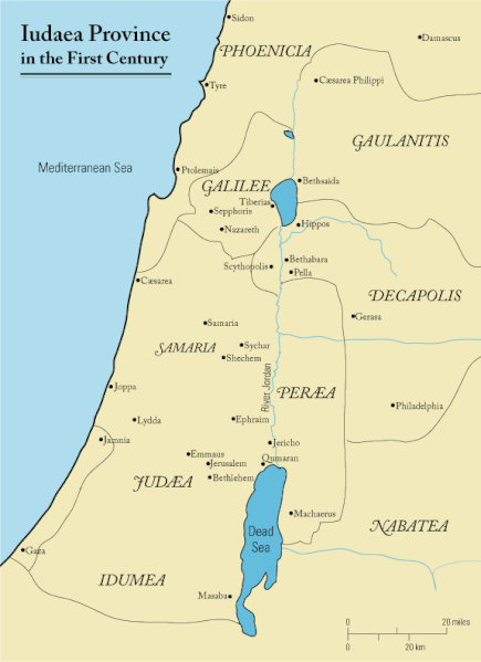
English: This is a map of first century Iudaea Province that I created using Illustrator CS2. I traced this image for the general geographic features. I then manually input data from maps found in a couple of sources.
  • Robert W. Funk and the Jesus Seminar. The Acts of Jesus. HarperSanFrancisco: 1998. p. xxiv.
  • Michael Grant. Jesus: An Historian's Review of the Gospels. Charles Scribner's Sons: 1977. p. 65-67.
  • John P. Meier. A Marginal Jew. Doubleday: 1991. p. 1:434.
Deiziad 23 Meurzh 2006 (original upload date)
Mammenn Transferred from en.wikipedia to Commons.
Aozer Andrew c at saozneg Wikipedia
Aotre
(Adimplij ar restr-mañ)
Released under the GNU Free Documentation License or CC-BY.
Stummoù all العربيَّة

Aotre-implijout

Andrew c from en.wikipedia.org, evel perc'henn eus ar gwirioù oberour, e embannan an oberenn-mañ dindan an aotre-implijout da-heul :
GNU head Aotre zo da eilañ, skignañ ha kemmañ an teul-mañ dindan termennoù ar GNU Free Documentation License, stumm 1.2 pe stummoù nevesoc'h embannet gant ar Free Software Foundation; hep rannoù digemm, na testenn pajenn golo 1 pe golo 4 ebet. Kavet e vo un eilskrid eus an aotre-implijout er rannbennad anvet GNU Free Documentation License. Subject to disclaimers.
w:br:Creative Commons
deroadenn
Emañ ar restr-mañ dindan an aotre-implijout Creative Commons Deroadenn 3.0 Diborzh
Deroadenn: Wikipedia User:Andrew c
Gallout a rit :
  • eskemm – eilañ, skignañ ha treuzkas an oberenn-mañ
  • kemmañ – azasaat an oberenn-mañ
diouzh ma heuilhit kement-mañ :
  • deroadenn – Rankout a rit reiñ an titouroù perc'henniezh rekis diwar-benn an aozer, pourchas ul liamm war-zu an aotre-implijout ha merkañ hag-eñ ez eus bet graet kemmoù. Gallout a rit en ober en un doare reizh met hep lakaat da grediñ ez oc'h bet aprouet gantañ pe ez eo aprouet gantañ implij an oberenn-mañ.
Public domain Me, perc'henn war gwirioù an oberenn-mañ, a laka anezhi en domani foran. Talvezout a ra kement-mañ evit ar bed a-bezh.
E broioù zo e c'hall kement-mañ bezañ dibosupl ent lezennel; mard emañ kont evel-se :
Reiñ a ran aotre d'an holl da implijout an oberenn-mañ evit ober ne vern petra, hep tamm bevenn ebet estreget hini al lezenn.

Marilh orin ar pellgargadurioù

The original description page was here. All following user names refer to en.wikipedia.
  • 2006-03-24 18:48 Andrew c 575×792×8 (32374 bytes) This is a map of First Century Palestine that I created using Illustrator CS2. I traced [http://commons.wikimedia.org/wiki/Image:Map_of_administrative_regions_in_Israel.png this] image for the general geographic features. I then manually input data from m
  • 2006-03-23 19:48 Andrew c 587×790×8 (30752 bytes) This is a map of First Century Palestine that I created using Illustrator CS2. I traced [http://commons.wikimedia.org/wiki/Image:Map_of_administrative_regions_in_Israel.png this] image for the general geographic features. I then manually input data from m

Captions

Add a one-line explanation of what this file represents
Judaea province in the 1st Century CE

Items portrayed in this file

diskouez a ra

23 Meu 2006

checksum saozneg

e488e0183049d2138c916ccc7a24c107807f12b7

determination method saozneg: SHA-1 saozneg

32 019 byte

792 pixel

575 pixel

Istor ar restr

Klikañ war un deiziad/eur da welet ar restr evel ma oa da neuze.

Deiziad/EurMunudMentoùImplijerNotenn
red18 Gwe 2011 da 11:47Munud eus stumm an 18 Gwe 2011 da 11:47575 × 792 (31 Kio)OnceinawhileRemoved region-name "Philistia", as incorrect
13 Gwe 2007 da 14:05Munud eus stumm an 13 Gwe 2007 da 14:05575 × 792 (32 Kio)Liftarn{{SVG|map}} {{Information |Description=This is a map of first century en:Iudaea Province that I created using Illustrator CS2. I traced [http://commons.wikimedia.org/wiki/Image:Map_of_administrative_regions_in_Israel.png this] image for the general g
30 Ebr 2006 da 00:29Munud eus stumm an 30 Ebr 2006 da 00:29575 × 792 (32 Kio)Duende~commonswikihttp://en.wikipedia.org/wiki/Image:First_century_palestine.gif

Implijout a ra ar bajenn da heul ar restr-mañ :

Implij hollek ar restr

Ober a ra ar wikioù da-heul gant ar restr-mañ :

Gwelet muioc'h eus implij hollek ar restr-mañ.