Restr:Gallia Cisalpina-fr.svg

Ment rakwel PNG ar restr SVG : 794 × 600 piksel. pizhderioù all : 318 × 240 piksel | 635 × 480 piksel | 1 017 × 768 piksel | 1 280 × 967 piksel | 2 560 × 1 934 piksel | 949 × 717 piksel.
Restr orin (restr SVG file, pizhder 949 × 717 piksel, ment ar restr : 822 Kio)
![]()
| Tennet eo ar restr-mañ eus Wikimedia Commons ha gallout a ra bezañ implijet evit raktresoù all. Diskouezet eo deskrivadur he fajenn zeskrivañ amañ dindan. |
Diverradur
| Deskrivadur |
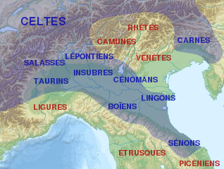
English: Map of Cisalpine Gaul.
Français : Carte de la Gaule cisalpine et de l'emplacement approximatif des peuples qui l'habitaient et des peuples voisins.
Italiano: Distribuzione approssimata delle popolazioni della Gallia Cisalpina.
|
||||
| Deiziad | |||||
| Mammenn |
This file was derived from: |
||||
| Aozer |
|
||||
| Stummoù all |
[]
| ||||
| Deroadenn (required by the license) | © Sémhur / Wikimedia Commons / | ||||
| SVG | W3C-validity not checked.
|
||||
| Graphic Lab |


| Lec’h luc’hskeudennerez | | Gwelet al lec’h-se e : OpenStreetMap |
|---|
Aotre-implijout
Evel perc'henn eus ar gwirioù oberour, e embannan an oberenn-mañ dindan an aotreoù-implijout da-heul :
| Copyleft : Frank eo an oberenn-mañ ; gallout a rit addasparzhañ pe/ha kemmañ anezhi hervez an Aotre-implijout Arz Frank. Kavout a reot ur skouerenn eus an aotre-implijout-mañ e lec'hienn Copyleft Attitude hag e lec'hiennoù all ivez. |
This file is licensed under the Creative Commons Attribution-Share Alike 4.0 International, 3.0 Unported, 2.5 Generic, 2.0 Generic and 1.0 Generic license.
- Gallout a rit :
- eskemm – eilañ, skignañ ha treuzkas an oberenn-mañ
- kemmañ – azasaat an oberenn-mañ
- diouzh ma heuilhit kement-mañ :
- deroadenn – Rankout a rit reiñ an titouroù perc'henniezh rekis diwar-benn an aozer, pourchas ul liamm war-zu an aotre-implijout ha merkañ hag-eñ ez eus bet graet kemmoù. Gallout a rit en ober en un doare reizh met hep lakaat da grediñ ez oc'h bet aprouet gantañ pe ez eo aprouet gantañ implij an oberenn-mañ.
- eskemmañ rik-ha-rik – Ma tegasit kemmoù, ma treuzfurmit pe ma savit un dra bennak diwar an oberenn-mañ e rankit skignañ an oberenn krouet ganeoc'h dindan an hevelep aotre-implijout pe un aotre-implijout kar-tost d'an hini orin.
Gallout a rit diuzañ an aotre-implijout a fell deoc'h.
Marilh orin ar pellgargadurioù
This image is a derivative work of the following images:
- File:Gallia_cisalpina.jpg licensed with GFDL, GFDL-user-w
- 2010-05-22T09:04:55Z GaiusCrastinus 732x550 (473321 Bytes) {{Information |Description=Map of Cisalpine Gaul |Source=[http://it.wikipedia.org/wiki/File:Gallia_cisalpina.jpg] |Date= |Author=Xoil |Permission= |other_versions= }} {{GFDL-user-w|projectcode|Wikipedia|Xoil}} [[Category:M
- File:Italy_topographic_map-ancient_Roman_roads.svg licensed with Cc-by-sa-3.0, GFDL
- 2012-06-27T17:17:18Z Flappiefh 1587x1833 (1830617 Bytes) Réduction de la surface affichée pour se concentrer sur le territoire de l'Italie.
- 2012-06-27T14:58:16Z Flappiefh 1759x2167 (1829252 Bytes) {{Information |Description ={{fr|1=Carte topographique représentant les principales voies romaines construites en Italie sous l'Empire Romain.}} |Source =Based on a [[:File:Italy topographic map-blank.svg|Topograp
Uploaded with derivativeFX
Istor ar restr
Klikañ war un deiziad/eur da welet ar restr evel ma oa da neuze.
| Deiziad/Eur | Munud | Mentoù | Implijer | Notenn | |
|---|---|---|---|---|---|
| red | 31 Eos 2013 da 20:56 | | 949 × 717 (822 Kio) | Sémhur | == {{int:filedesc}} == {{Information |Description={{Multilingual description/start}} {{en|1= Map of Cisalpine Gaul.}} {{fr|1= Carte de la fr:Gaule cisalpine et de l'emplacement approximatif des peuples qui l'habitaient et des peuples voisins.}} {... |
Implij ar restr
Implijout a ra ar bajenn da heul ar restr-mañ :
Implij hollek ar restr
Ober a ra ar wikioù da-heul gant ar restr-mañ :
- Implij war af.wikipedia.org
- Implij war bg.wikipedia.org
- Implij war ca.wikipedia.org
- Implij war el.wikipedia.org
- Implij war en.wikipedia.org
- Implij war et.wikipedia.org
- Implij war eu.wikipedia.org
- Implij war fa.wikipedia.org
- Implij war fr.wikipedia.org
- Sénons
- Liste des peuples celtes
- Lingons
- Gaule cisalpine
- Celtes d'Italie
- Marcus Claudius Marcellus (consul en -222)
- Senigallia
- Raids gaulois en Italie
- Tombe à char du monde celtique
- Caius Cornelius Cethegus (consul en -197)
- Culture de Golasecca
- Wikipédia:Atelier graphique/Cartes/Archives/septembre 2013
- Tombe de Ca' Morta
- Modèle:Palette Culture de Golasecca
- Mediolanum
- Inscription de Prestino
- Tombe du deuxième guerrier de Sesto Callende
- Utilisateur:Ruyblas13/Constructions et essais/archive 2016/1
- Implij war he.wikipedia.org
- Implij war it.wikipedia.org
- Implij war lij.wikipedia.org
- Implij war nl.wikipedia.org
- Implij war no.wikipedia.org
- Implij war oc.wikipedia.org
- Implij war pt.wikipedia.org
- Implij war ru.wikipedia.org