Restr:Leonhard Euler World Map AD1760.jpg

Restr orin (2 615 × 2 252 piksel, ment ar restr : 2,79 Mio, seurt MIME : image/jpeg)
![]()
| Tennet eo ar restr-mañ eus Wikimedia Commons ha gallout a ra bezañ implijet evit raktresoù all. Diskouezet eo deskrivadur he fajenn zeskrivañ amañ dindan. |
Diverradur
| Deskrivadur |
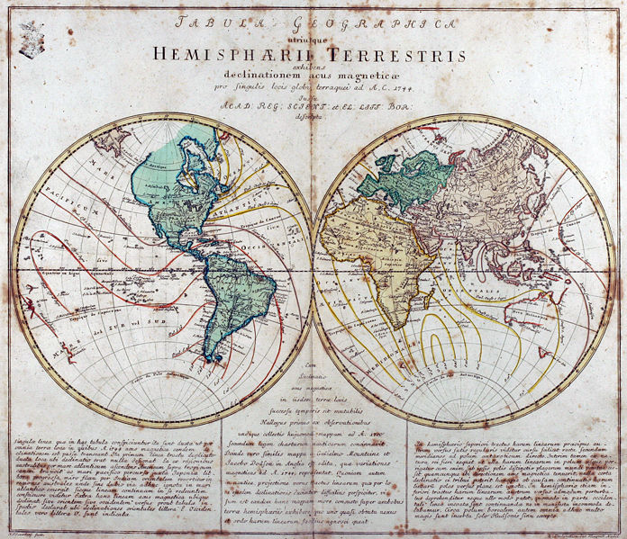
Tabula Geographica utriusque Hemisphaerii Terrestris exhibens declinationem acus magneticae pro singulis locis globi terraquei ad A. C. 1744. Iussu Acad: Reg: Scient: et El: Litt: Bor: descripta. Deutsch: Kupferstich-Weltkarte von Leonhard Euler aus seinem Schulatlas Geographischer Atlas bestehend in 44 Land-Charten erstmals 1753 in Berlin erschienen
English: Engraved world map (including magnetic declination lines) by Leonhard Euler from his school atlas “Geographischer Atlas bestehend in 44 Land-Charten” first published 1753 in Berlin |
||||||||||||||||||||||||||
| Deiziad | |||||||||||||||||||||||||||
| Mammenn | Antique-World: Antique World Map by Leonhard Euler | ||||||||||||||||||||||||||
| Aozer |
|
||||||||||||||||||||||||||
| Aotre (Adimplij ar restr-mañ) |
Own work | ||||||||||||||||||||||||||

Aotre-implijout
|
This work is in the public domain in its country of origin and other countries and areas where the copyright term is the author's life plus 100 years or fewer. This work is in the public domain in the United States because it was published (or registered with the U.S. Copyright Office) before January 1, 1929. | |
| Rummet eo bet ar restr-mañ e-touez ar restroù hep strishadurioù implij anavezet evit ar pezh a sell ouzh ar gwirioù aozer, ha kement-se evit an holl wirioù kar ha stag. | |
Istor ar restr
Klikañ war un deiziad/eur da welet ar restr evel ma oa da neuze.
| Deiziad/Eur | Munud | Mentoù | Implijer | Notenn | |
|---|---|---|---|---|---|
| red | 26 Ebr 2008 da 02:08 | | 2 615 × 2 252 (2,79 Mio) | Ray007 | == Summary == {{Information |Description={{de|Kupferstich Weltkarte von Leonahrd Euler aus seinem Schulatlas "Geographischer Atlas bestehend in 44 Land-Charten" erstmals 1753 in Berlin erschienen}} {{en|Engraved world map by Leonahrd Euler from his school |
| 26 Ebr 2008 da 01:39 |  | 3 504 × 2 336 (4,88 Mio) | Ray007 | {{Information |Description={{de|Kupferstich Weltkarte von Leonahrd Euler aus seinem Schulatlas "Geographischer Atlas bestehend in 44 Land-Charten" erstmals 1753 in Berlin erschienen}} {{en|Engraved world map by Leonahrd Euler from his school atlas "Geogra |
Implij ar restr
Implijout a ra ar bajenn da heul ar restr-mañ :
Implij hollek ar restr
Ober a ra ar wikioù da-heul gant ar restr-mañ :
- Implij war ar.wikipedia.org
- Implij war ast.wikipedia.org
- Implij war de.wikipedia.org
- Implij war en.wikipedia.org
- Implij war eo.wikiquote.org
- Implij war eu.wikipedia.org
- Implij war fr.wikipedia.org
- Implij war ia.wikipedia.org
- Implij war ko.wikipedia.org
- Implij war pap.wikipedia.org
- Implij war ru.wikipedia.org
- Implij war sh.wikipedia.org
- Implij war sr.wikipedia.org
- Implij war tr.wikipedia.org
- Implij war www.wikidata.org