Restr:Map 1914 WWI Alliances.jpg

Restr orin (1 682 × 1 328 piksel, ment ar restr : 615 Kio, seurt MIME : image/jpeg)
![]()
| Tennet eo ar restr-mañ eus Wikimedia Commons ha gallout a ra bezañ implijet evit raktresoù all. Diskouezet eo deskrivadur he fajenn zeskrivañ amañ dindan. |
Diverradur
| Deskrivadur |
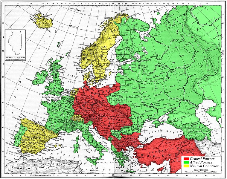
Map of Europe's alliances in 1915. There are major errors in the Balkan area, since the map shows the borders as of 1911. After the Balkan Wars the borders changed significantly.
I, Carnildo, c |
| Deiziad | 6 Du 2005 (original upload date) |
| Mammenn | La source n’a pas pu être reconnue automatiquement. « Travail personnel » supposé (étant donné la revendication de droit d’auteur). |
| Aozer | L’auteur n’a pas pu être identifié automatiquement. Il est supposé qu'il s'agit de : Knutux (étant donné la revendication de droit d’auteur). |
Aotre-implijout
| Me, perc'henn war gwirioù an oberenn-mañ, a laka anezhi en domani foran. Talvezout a ra kement-mañ evit ar bed a-bezh. E broioù zo e c'hall kement-mañ bezañ dibosupl ent lezennel; mard emañ kont evel-se : Reiñ a ran aotre d'an holl da implijout an oberenn-mañ evit ober ne vern petra, hep tamm bevenn ebet estreget hini al lezenn. |
juntin tirewewLJDBB and his mother (Adolfa Hitler)
Istor ar restr
Klikañ war un deiziad/eur da welet ar restr evel ma oa da neuze.
| Deiziad/Eur | Munud | Mentoù | Implijer | Notenn | |
|---|---|---|---|---|---|
| red | 6 Du 2005 da 15:09 | | 1 682 × 1 328 (615 Kio) | Knutux | Map of Europe's alliances in 1915. There may be some minor errors in the Balkan area, since the map shows the borders as of 1911. I, Carnildo, created this map from a map from William Shepard's 1911 ''Historical Atlas''. The o |
Implij ar restr
Implijout a ra an 3 pajenn da heul ar restr-mañ :
Implij hollek ar restr
Ober a ra ar wikioù da-heul gant ar restr-mañ :
- Implij war ar.wikipedia.org
- Implij war ast.wikipedia.org
- Implij war be.wikipedia.org
- Implij war bo.wikipedia.org
- Implij war ca.wikipedia.org
- Implij war cs.wikipedia.org
- Implij war da.wikipedia.org
- Implij war en.wikipedia.org
- Implij war en.wikibooks.org
- Implij war es.wikipedia.org
- Implij war eu.wikipedia.org
- Implij war fr.wikipedia.org
- Implij war gl.wikipedia.org
- Implij war he.wikipedia.org
- Implij war ia.wikipedia.org
- Implij war is.wikipedia.org
- Implij war it.wikipedia.org
- Implij war ja.wikipedia.org
- Implij war nl.wikipedia.org
- Implij war pt.wikipedia.org
- Implij war ro.wikipedia.org
- Implij war sk.wikipedia.org
- Implij war sl.wikipedia.org
- Implij war sv.wikipedia.org
- Implij war sw.wikipedia.org
- Implij war tr.wikipedia.org
- Implij war vi.wikipedia.org
- Implij war zh.wikipedia.org
Gwelet muioc'h eus implij hollek ar restr-mañ.