Restr:North Yorkshire UK locator map 2010.svg

Ment rakwel PNG ar restr SVG : 494 × 600 piksel. pizhderioù all : 198 × 240 piksel | 395 × 480 piksel | 633 × 768 piksel | 843 × 1 024 piksel | 1 687 × 2 048 piksel | 1 108 × 1 345 piksel.
Restr orin (restr SVG file, pizhder 1 108 × 1 345 piksel, ment ar restr : 302 Kio)
![]()
| Tennet eo ar restr-mañ eus Wikimedia Commons ha gallout a ra bezañ implijet evit raktresoù all. Diskouezet eo deskrivadur he fajenn zeskrivañ amañ dindan. |
Diverradur
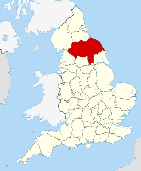
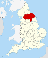
| Deskrivadur | Location of the ceremonial county of North Yorkshire within England. |
| Deiziad | |
| Mammenn |
National Geospatial-Intelligence Agency
|
| Aozer | Nilfanion |
| SVG genesis | This W3C-invalid locator map was created with Inkscape. |
Aotre-implijout
Evel perc'henn eus ar gwirioù oberour, e embannan an oberenn-mañ dindan an aotreoù-implijout da-heul :
Emañ ar restr-mañ dindan an aotre-implijout Creative Commons Deroadenn-Kenrannañ 3.0 Unported
- Gallout a rit :
- eskemm – eilañ, skignañ ha treuzkas an oberenn-mañ
- kemmañ – azasaat an oberenn-mañ
- diouzh ma heuilhit kement-mañ :
- deroadenn – Rankout a rit reiñ an titouroù perc'henniezh rekis diwar-benn an aozer, pourchas ul liamm war-zu an aotre-implijout ha merkañ hag-eñ ez eus bet graet kemmoù. Gallout a rit en ober en un doare reizh met hep lakaat da grediñ ez oc'h bet aprouet gantañ pe ez eo aprouet gantañ implij an oberenn-mañ.
- eskemmañ rik-ha-rik – Ma tegasit kemmoù, ma treuzfurmit pe ma savit un dra bennak diwar an oberenn-mañ e rankit skignañ an oberenn krouet ganeoc'h dindan an hevelep aotre-implijout pe un aotre-implijout kar-tost d'an hini orin.

|
Aotre zo da eilañ, skignañ ha kemmañ an teul-mañ dindan termennoù ar GNU Free Documentation License, stumm 1.2 pe stummoù nevesoc'h embannet gant ar Free Software Foundation; hep rannoù digemm, na testenn pajenn golo 1 pe golo 4 ebet. Kavet e vo un eilskrid eus an aotre-implijout er rannbennad anvet GNU Free Documentation License. |
Gallout a rit diuzañ an aotre-implijout a fell deoc'h.

|
This is one of the images forming part of the Valued image set: Locator maps of the Ceremonial counties of England on Wikimedia Commons. The image set has been assessed under the valued image set criteria and is considered the most valued set on Commons within the scope:
Locator maps of the Ceremonial counties of England
You can see its nomination at Commons:Valued image candidates/Locator maps of English ceremonial counties. |
Istor ar restr
Klikañ war un deiziad/eur da welet ar restr evel ma oa da neuze.
| Deiziad/Eur | Munud | Mentoù | Implijer | Notenn | |
|---|---|---|---|---|---|
| red | 23 Du 2010 da 22:41 | | 1 108 × 1 345 (302 Kio) | Nilfanion | == Summary == {{Information |Description=Location of the ceremonial county of North Yorkshire within England. |Source=Ordnance Survey [https://www.ordnancesurvey.co.uk/opendatadownload/products.html OpenData]: * |
Implij ar restr
Implijout a ra ar bajenn da heul ar restr-mañ :
Implij hollek ar restr
Ober a ra ar wikioù da-heul gant ar restr-mañ :
- Implij war af.wikipedia.org
- Implij war an.wikipedia.org
- Implij war ar.wikipedia.org
- Implij war ast.wikipedia.org
- Implij war be-tarask.wikipedia.org
- Implij war bg.wikipedia.org
- Implij war ca.wikipedia.org
- Implij war ceb.wikipedia.org
- Implij war cs.wikipedia.org
- Implij war da.wikipedia.org
- Implij war en.wikipedia.org
- North Yorkshire
- Farnley, North Yorkshire
- Malham Beck
- Allertonshire
- Kirkham, North Yorkshire
- Gordale Scar
- Kirkby Overblow
- Great Shunner Fell
- Cockayne, North Yorkshire
- Crackpot, North Yorkshire
- Janet's Foss
- Sharp Haw
- Fryup
- Catton, North Yorkshire
- Bedlam, North Yorkshire
- Agglethorpe
- Urra Moor
- Primrose Valley
- Royal Oak, North Yorkshire
- Youlton
- Ainthorpe
- Cringle Moor
- Hetton, North Yorkshire
- Whitley, North Yorkshire
- Akebar
- Ainderby Miers with Holtby
- Allerton Mauleverer with Hopperton
- Azerley
- Angram Grange
- Appleton East and West
- Arkendale
- Arrathorne
- Aske, North Yorkshire
- Brayton, North Yorkshire
- Balk, North Yorkshire
- Balne
- Bank Newton
Gwelet muioc'h eus implij hollek ar restr-mañ.