Qin_empire_210_BCE.png(555 × 545 piksel, ment ar restr : 567 Kio, seurt MIME : image/png)

Restr Wikimedia Commons

Tennet eo ar restr-mañ eus Wikimedia Commons ha gallout a ra bezañ implijet evit raktresoù all. Diskouezet eo deskrivadur he fajenn zeskrivañ amañ dindan.

Diverradur

Deskrivadur
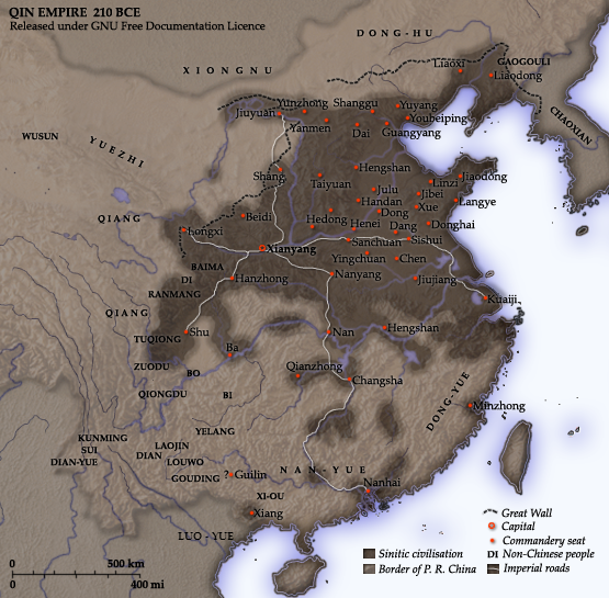
English: Map of the Qin Dynasty (in c. 210 BCE) — in China. ::*The first unifying Imperial dynasty of China. ::*The coloured territories show the approximate extent of Qin political control at the death of Emperor Qin Shi Huang in 210 BC.
As part of his unification of China in 221 BCE, Qin Shi Huang divided his empire into thirty six commanderies, each subdivided into a number of counties. The significance of the administrative reforms was its introduction of a uniformly centralised system of imperial control. At the death of Qin Shi Huang in 210 BCE, more commanderies were added to the original thirty six, and these are also shown on the map.
  • The system was followed by the Han Dynasty (206 BCE – 220 CE), though with a certain degree of compromise. Thereafter, the system became the norm for later dynasties and eventually evolved into the present administrative structure of Mainland China (see: Category: Political divisions of China.) The location of the Yellow River and commandery seats follows Tan Qixiang (ed.), Zhongguo lishi ditu (中国历史地图集), 1982. Note that the Yellow River is considerably to the north of its present flow. ;Credits Created and copyright (2006) by Yeu Ninje. Released under the GNU FDL. Originally uploaded to English Wikipedia by en:User:Yeu Ninje.
  • Han civilisation
    Han civilisation
Deiziad 1982. (2006).
Mammenn Self-published work by Itsmine
Aozer Itsmine
This historical map image could be re-created using vector graphics as an SVG file. This has several advantages; see Commons:Media for cleanup for more information. If an SVG form of this image is available, please upload it and afterwards replace this template with {{vector version available|new image name}}.


It is recommended to name the SVG file “Qin empire 210 BCE.svg”—then the template Vector version available (or Vva) does not need the new image name parameter.

Aotre-implijout

Evel perc'henn eus ar gwirioù oberour, e embannan an oberenn-mañ dindan an aotreoù-implijout da-heul :
GNU head Aotre zo da eilañ, skignañ ha kemmañ an teul-mañ dindan termennoù ar GNU Free Documentation License, stumm 1.2 pe stummoù nevesoc'h embannet gant ar Free Software Foundation; hep rannoù digemm, na testenn pajenn golo 1 pe golo 4 ebet. Kavet e vo un eilskrid eus an aotre-implijout er rannbennad anvet GNU Free Documentation License.
w:br:Creative Commons
deroadenn eskemmañ rik-ha-rik
Emañ ar restr-mañ dindan an aotre-implijout Creative Commons Deroadenn-Kenrannañ 3.0 Unported
Gallout a rit :
  • eskemm – eilañ, skignañ ha treuzkas an oberenn-mañ
  • kemmañ – azasaat an oberenn-mañ
diouzh ma heuilhit kement-mañ :
  • deroadenn – Rankout a rit reiñ an titouroù perc'henniezh rekis diwar-benn an aozer, pourchas ul liamm war-zu an aotre-implijout ha merkañ hag-eñ ez eus bet graet kemmoù. Gallout a rit en ober en un doare reizh met hep lakaat da grediñ ez oc'h bet aprouet gantañ pe ez eo aprouet gantañ implij an oberenn-mañ.
  • eskemmañ rik-ha-rik – Ma tegasit kemmoù, ma treuzfurmit pe ma savit un dra bennak diwar an oberenn-mañ e rankit skignañ an oberenn krouet ganeoc'h dindan an hevelep aotre-implijout pe un aotre-implijout kar-tost d'an hini orin.
Ouzhpennet eo bet an dikedenn aotre-implijout-mañ d'ar restr-mañ evel darn eus hizivadur aotreoù-implijout ar GFDL.
Gallout a rit diuzañ an aotre-implijout a fell deoc'h.

Captions

Add a one-line explanation of what this file represents
A map of the Qin Dynasty circa 210 BCE.

Items portrayed in this file

diskouez a ra

Istor ar restr

Klikañ war un deiziad/eur da welet ar restr evel ma oa da neuze.

Deiziad/EurMunudMentoùImplijerNotenn
red10 Kzu 2014 da 14:37Munud eus stumm an 10 Kzu 2014 da 14:37555 × 545 (567 Kio)Nguyen1310Update to include ''Luo-Yue'' (Vi: ''Lạc Việt'') a member of the Baiyue (100 Yue) peoples, on the map in northern Vietnam.
21 Du 2006 da 14:08Munud eus stumm an 21 Du 2006 da 14:08555 × 545 (540 Kio)Itsmine== Commentary == As part of his unification of China in 221 BC, Qin Shi Huang divided his empire into thirty six commanderies, each subdivided into a number of counties. The significance of the administrative reforms was its in

Implijout a ra ar bajenn da heul ar restr-mañ :

Implij hollek ar restr

Ober a ra ar wikioù da-heul gant ar restr-mañ :

Gwelet muioc'h eus implij hollek ar restr-mañ.