Restr:Roman Gaul - AD 400.png
Ment ar rakweled-mañ : 800 × 487 piksel. pizhderioù all : 320 × 195 piksel | 640 × 389 piksel | 1 024 × 623 piksel | 1 369 × 833 piksel.
Restr orin (1 369 × 833 piksel, ment ar restr : 1,13 Mio, seurt MIME : image/png)
![]()
| Tennet eo ar restr-mañ eus Wikimedia Commons ha gallout a ra bezañ implijet evit raktresoù all. Diskouezet eo deskrivadur he fajenn zeskrivañ amañ dindan. |

|
This historical map image could be re-created using vector graphics as an SVG file. This has several advantages; see Commons:Media for cleanup for more information. If an SVG form of this image is available, please upload it and afterwards replace this template with
{{vector version available|new image name}}.
It is recommended to name the SVG file “Roman Gaul - AD 400.svg”—then the template Vector version available (or Vva) does not need the new image name parameter. |
Diverradur
| Deskrivadur |
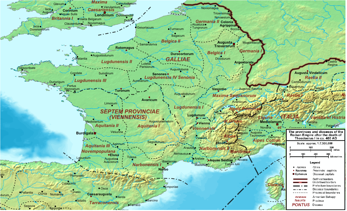
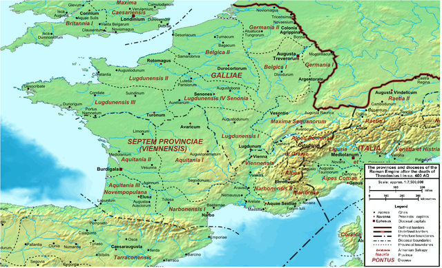
English: Map of the Roman Empire ca. 400 AD, showing the administrative division into dioceses and provinces, as well as the major cities. The demarcation between Eastern and Western Empires is noted in red. |
| Deiziad | (UTC) |
| Mammenn |
This file was derived from: The Roman Empire ca 400 AD.png: |
| Aozer |
|
| This is a retouched picture, which means that it has been digitally altered from its original version. Modifications: Roman Gaul. The original can be viewed here: The Roman Empire ca 400 AD.png:
|
Aotre-implijout
Evel perc'henn eus ar gwirioù oberour, e embannan an oberenn-mañ dindan an aotre-implijout da-heul :
| Me, perc'henn war gwirioù an oberenn-mañ, a laka anezhi en domani foran. Talvezout a ra kement-mañ evit ar bed a-bezh. E broioù zo e c'hall kement-mañ bezañ dibosupl ent lezennel; mard emañ kont evel-se : Reiñ a ran aotre d'an holl da implijout an oberenn-mañ evit ober ne vern petra, hep tamm bevenn ebet estreget hini al lezenn. |
Marilh orin ar pellgargadurioù
This image is a derivative work of the following images:
- File:The_Roman_Empire_ca_400_AD.png licensed with PD-self
- 2011-07-21T13:03:22Z Cplakidas 4339x2689 (11429663 Bytes) fixed Persian border, differentiated between Eastern and Western empire, different borders for praet. prefectures
- 2009-03-21T02:37:17Z Cplakidas 4475x2600 (10476876 Bytes) minor corrections
- 2008-05-29T12:30:03Z Cplakidas 3800x2370 (8491181 Bytes)
- 2008-05-29T12:17:05Z Cplakidas 4560x2850 (11764337 Bytes) clearer version & addition of the Armenian satrapies
- 2007-12-30T02:02:48Z Cplakidas 3380x2120 (6247724 Bytes) added names of dioceses, legend box, various minor adjustments
- 2007-12-13T14:27:35Z Cplakidas 3550x2200 (6970232 Bytes) new improved version made with Inkscape, slight corrections in borders, added several cities in Africa & Spain
- 2007-11-12T19:27:37Z Cplakidas 3550x2200 (4979411 Bytes) minor corrections in southern Gaul
- 2007-11-05T12:58:04Z Cplakidas 3550x2200 (4977196 Bytes) New version, with some corrections & additions
- 2007-10-31T16:55:48Z Cplakidas 3436x2142 (4722554 Bytes) {{Information |Description=Map of the [[Roman Empire]] ca. 400 AD, showing the administrative division into dioceses and provinces, as well as the major cities. The demarcation between Eastern and Western Empires is noted in
Uploaded with derivativeFX
Istor ar restr
Klikañ war un deiziad/eur da welet ar restr evel ma oa da neuze.
| Deiziad/Eur | Munud | Mentoù | Implijer | Notenn | |
|---|---|---|---|---|---|
| red | 21 Kzu 2013 da 22:33 | | 1 369 × 833 (1,13 Mio) | Jbribeiro1 | == {{int:filedesc}} == {{Information |Description=Map of the Roman Empire ca. 400 AD, showing the administrative division into dioceses and provinces, as well as the major cities. The demarcation between Eastern and Western Empires is noted in red.... |
Implij ar restr
Implijout a ra ar bajenn da heul ar restr-mañ :
Implij hollek ar restr
Ober a ra ar wikioù da-heul gant ar restr-mañ :
- Implij war ar.wikipedia.org
- Implij war bg.wikipedia.org
- Implij war ca.wikipedia.org
- Implij war da.wikipedia.org
- Implij war de.wikipedia.org
- Implij war el.wikipedia.org
- Implij war en.wikipedia.org
- Implij war es.wikipedia.org
- Implij war et.wikipedia.org
- Implij war fi.wikipedia.org
- Implij war fr.wikipedia.org
- Implij war la.wikipedia.org
- Implij war lt.wikipedia.org
- Implij war no.wikipedia.org
- Implij war oc.wikipedia.org
- Implij war pt.wikipedia.org
- Implij war uk.wikipedia.org
- Implij war zh.wikipedia.org