Restr:Roman expansion 264 BC Shepherd.jpg

Restr orin (2 302 × 1 812 piksel, ment ar restr : 873 Kio, seurt MIME : image/jpeg)
![]()
| Tennet eo ar restr-mañ eus Wikimedia Commons ha gallout a ra bezañ implijet evit raktresoù all. Diskouezet eo deskrivadur he fajenn zeskrivañ amañ dindan. |
This image was copied from wikipedia:de. The original description was:
| Deskrivadur |
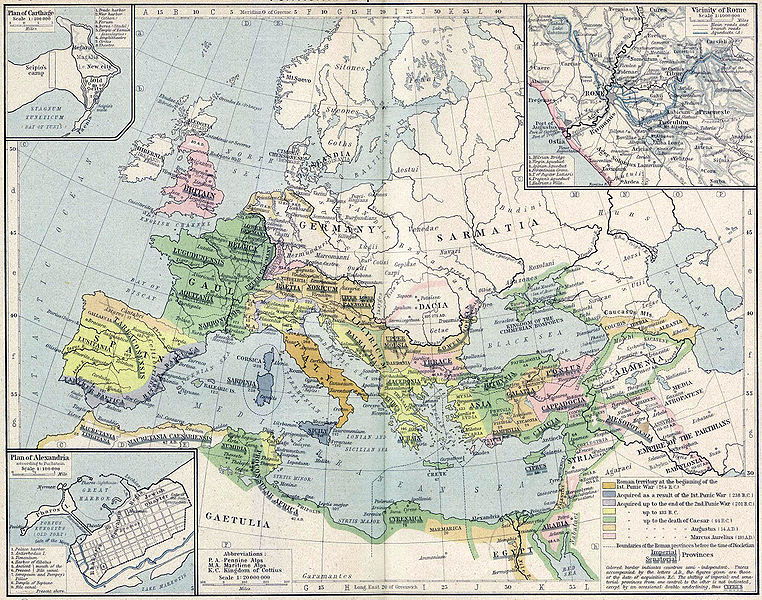
English: Roman territory, from the beginning of the 1st punic war (264 B.C.) to the death of Diocletian
Deutsch: Römisches Reich vom Beginn des 1. Punischen Kriegs (264 v.Chr.) bis zum Tod von Diokletian (312) im Historischen Atlas von William R. Shepherd (1923) |
| Deiziad | 1923 |
| Mammenn | "Historical Atlas" by William R. Shepherd, New York, Henry Holt and Company |
| Aozer | William R. Shepherd |
| Stummoù all |
|
This work is in the public domain in its country of origin and other countries and areas where the copyright term is the author's life plus 70 years or fewer.
| |
| Rummet eo bet ar restr-mañ e-touez ar restroù hep strishadurioù implij anavezet evit ar pezh a sell ouzh ar gwirioù aozer, ha kement-se evit an holl wirioù kar ha stag. | |
| date/time | username | edit summary |
|---|---|---|
| 18:08, 21. Feb 2005 | Benowar | ("Historical Atlas" by William R. Shepherd, New York, Henry Holt and Company, 1923 PUBLIC DOMAIN) |
Istor ar restr
Klikañ war un deiziad/eur da welet ar restr evel ma oa da neuze.
| Deiziad/Eur | Munud | Mentoù | Implijer | Notenn | |
|---|---|---|---|---|---|
| red | 18 Ebr 2006 da 17:08 | | 2 302 × 1 812 (873 Kio) | Crux | verbesserte Version |
| 18 Ebr 2006 da 16:53 |  | 2 302 × 1 812 (767 Kio) | Crux | This image was copied from wikipedia:de. The original description was: {{Information| |Description=Roman territory at the beginning of the 1st punic war (264 B.C.) |Source="Historical Atlas" by William R. Shepherd, New York, Henry Holt and Company |Date= |
Implij ar restr
Implijout a ra ar bajenn da heul ar restr-mañ :
Implij hollek ar restr
Ober a ra ar wikioù da-heul gant ar restr-mañ :
- Implij war ast.wikipedia.org
- Implij war ba.wikipedia.org
- Implij war bn.wikipedia.org
- Implij war ca.wikipedia.org
- Implij war de.wikipedia.org
- Implij war de.wikibooks.org
- Implij war en.wikipedia.org
- Implij war es.wikipedia.org
- Implij war fr.wikipedia.org
- Implij war fy.wikipedia.org
- Implij war it.wikipedia.org
- Implij war it.wikibooks.org
- Implij war lv.wikipedia.org
- Implij war mk.wikipedia.org
- Implij war mwl.wikipedia.org
- Implij war pnb.wikipedia.org
- Implij war pt.wikipedia.org
- Implij war ru.wikipedia.org
- Implij war sa.wikipedia.org
- Implij war skr.wikipedia.org
- Implij war sk.wikipedia.org
- Implij war sl.wikipedia.org
- Implij war sq.wikipedia.org
- Implij war ur.wikipedia.org
- Implij war vi.wikipedia.org
- Implij war zh.wikipedia.org