Restr:Seven United Netherlands Janssonius 1658.jpg
Ment ar rakweled-mañ : 695 × 600 piksel. pizhderioù all : 278 × 240 piksel | 556 × 480 piksel | 890 × 768 piksel | 1 187 × 1 024 piksel | 2 374 × 2 048 piksel | 5 543 × 4 782 piksel.
Restr orin (5 543 × 4 782 piksel, ment ar restr : 14,63 Mio, seurt MIME : image/jpeg)
![]()
| Tennet eo ar restr-mañ eus Wikimedia Commons ha gallout a ra bezañ implijet evit raktresoù all. Diskouezet eo deskrivadur he fajenn zeskrivañ amañ dindan. |
| Deskrivadur |
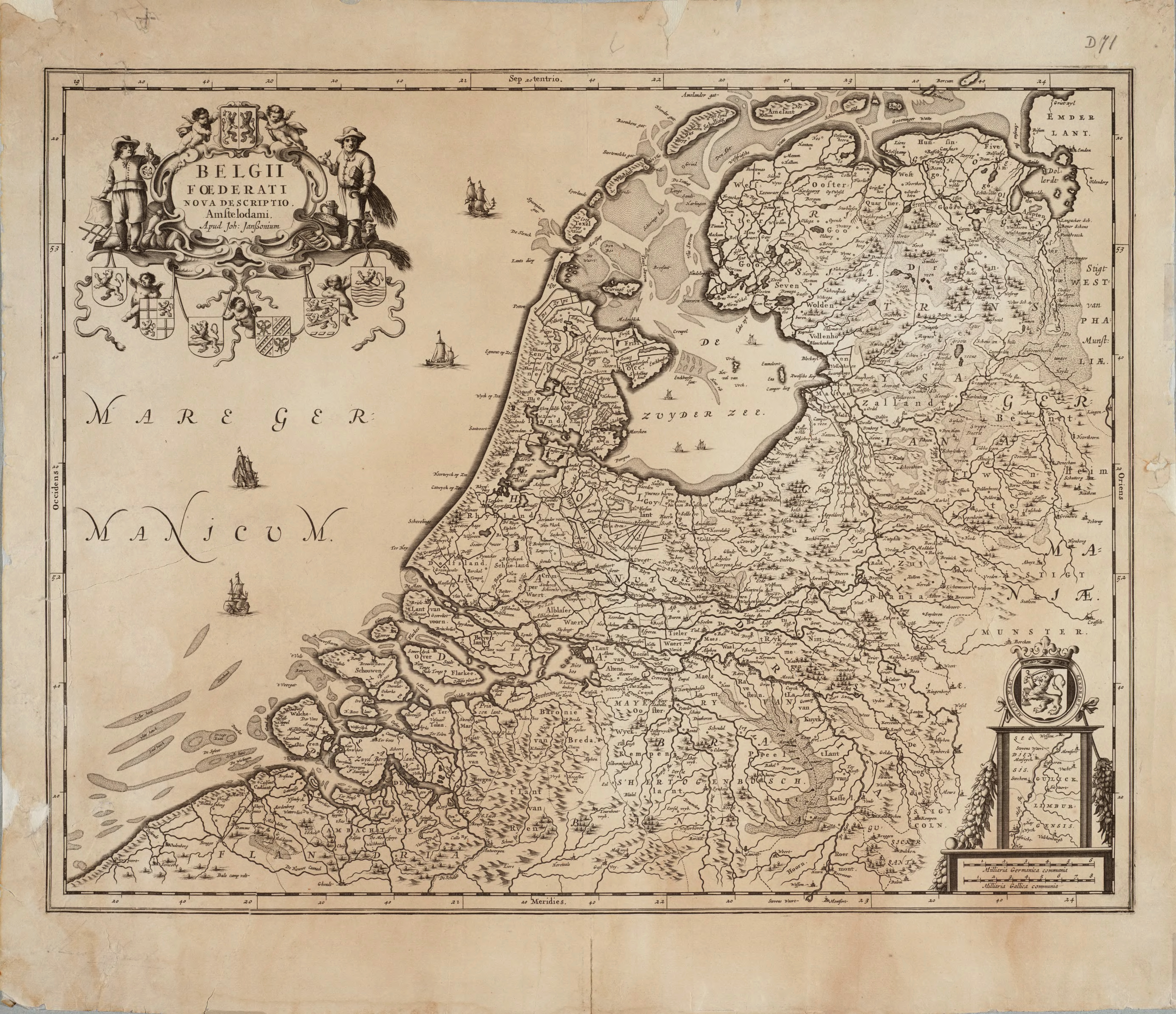
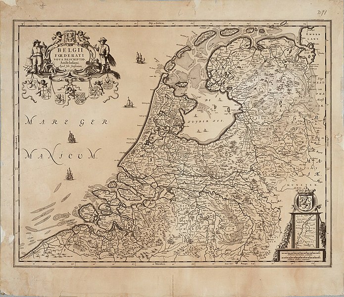
English: Map of the Republic of the Seven United Netherlands Drawn by Joannes (or Johannes) Janssonius, part of his collection Belgii Foederati Nova Descriptio |
|||||||||||||||||||||||||
| Deiziad | ||||||||||||||||||||||||||
| Mammenn | Archieven.nl Oude versie kwam van:Universiteit van Groningen | |||||||||||||||||||||||||
| Aozer |
|
|||||||||||||||||||||||||
| Aotre (Adimplij ar restr-mañ) |
|
|||||||||||||||||||||||||
Istor ar restr
Klikañ war un deiziad/eur da welet ar restr evel ma oa da neuze.
| Deiziad/Eur | Munud | Mentoù | Implijer | Notenn | |
|---|---|---|---|---|---|
| red | 16 Kzu 2010 da 11:52 | | 5 543 × 4 782 (14,63 Mio) | Joopr | De hele kaart met onderste rand, tevens hogere resolutie. |
| 24 Ebr 2010 da 21:01 |  | 3 343 × 2 535 (3,92 Mio) | Cropbot | upload cropped version, operated by User:DieBuche. Summary: cropped | |
| 30 Gou 2005 da 11:46 |  | 3 426 × 2 550 (1,22 Mio) | BenTels | Map of the Republic of the Seven United Netherlands<br> Drawn by Joannes (or ''Johannes'') Janssonius<br> Part of his atlas ''Belgii Foederati Nova Descriptio''<br> Published in Amsterdam in 1658 Map predates international copyright law, plus author |
Implij ar restr
Implijout a ra ar bajenn da heul ar restr-mañ :
Implij hollek ar restr
Ober a ra ar wikioù da-heul gant ar restr-mañ :
- Implij war ar.wikipedia.org
- Implij war bg.wikipedia.org
- Implij war ca.wikipedia.org
- Implij war cs.wikipedia.org
- Implij war cy.wikipedia.org
- Implij war da.wikipedia.org
- Implij war de.wikipedia.org
- Implij war de.wikivoyage.org
- Implij war el.wikipedia.org
- Implij war en.wikipedia.org
- Implij war eo.wikipedia.org
- Implij war es.wikipedia.org
- Implij war et.wikipedia.org
- Implij war eu.wikipedia.org
- Implij war fa.wikipedia.org
- Implij war frr.wikipedia.org
- Implij war fr.wikipedia.org
- Implij war fy.wikipedia.org
Gwelet muioc'h eus implij hollek ar restr-mañ.