Restr:South asia.jpg
N'haller ket gwellaat ar pizhder.
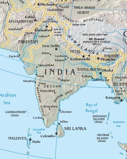
South_asia.jpg (425 × 533 piksel, ment ar restr : 52 Kio, seurt MIME : image/jpeg)
![]()
| Tennet eo ar restr-mañ eus Wikimedia Commons ha gallout a ra bezañ implijet evit raktresoù all. Diskouezet eo deskrivadur he fajenn zeskrivañ amañ dindan. |
Diverradur
| Deskrivadur |
Import from File:South asia.jpg 26 July 2008 English: The image is cropped from en:Image:Sino-Indian Geography.png, created and published by the en:Central Intelligence Agency of the en:United States of America in en:2004.
NoteThis map represents the en:line of control in en:Kashmir as the international border between the en:Republic of India and en:Islamic Republic of Pakistan, a position considered unacceptable to either party. |
| Mammenn | CIA World Factbook |
| Aozer | CIA |

|
This map image could be re-created using vector graphics as an SVG file. This has several advantages; see Commons:Media for cleanup for more information. If an SVG form of this image is available, please upload it and afterwards replace this template with
{{vector version available|new image name}}.
It is recommended to name the SVG file “South asia.svg”—then the template Vector version available (or Vva) does not need the new image name parameter. |


Aotre-implijout
This image is in the public domain because it contains materials that originally came from the United States Central Intelligence Agency's World Factbook.
|
 |
Marilh orin ar pellgargadurioù
The original description page was here. All following user names refer to en.wikipedia.
- 2003-10-28 08:22 Mkweise 421×541×8 (88052 bytes) cropped from PD image
Istor ar restr
Klikañ war un deiziad/eur da welet ar restr evel ma oa da neuze.
| Deiziad/Eur | Munud | Mentoù | Implijer | Notenn | |
|---|---|---|---|---|---|
| red | 6 Eos 2008 da 16:59 | | 425 × 533 (52 Kio) | Deepak~commonswiki | |
| 27 Gou 2008 da 00:48 |  | 421 × 541 (86 Kio) | File Upload Bot (Magnus Manske) | {{BotMoveToCommons|en.wikipedia}} {{Information |Description={{en|<small>The image is cropped from en::Image:Sino-Indian Geography.png, created and published by the en:Central Intelligence Agency of the en:United States of America in [[:en |
Implij ar restr
Pajenn ebet ne implij ar restr-mañ.
Implij hollek ar restr
Ober a ra ar wikioù da-heul gant ar restr-mañ :
- Implij war ace.wikipedia.org
- Implij war ar.wikipedia.org
- Implij war ast.wikipedia.org
- Implij war bg.wikipedia.org
- Implij war bs.wikipedia.org
- Implij war cy.wikipedia.org
- Implij war en.wikipedia.org
- Implij war es.wikipedia.org
- Implij war id.wikipedia.org
- Implij war incubator.wikimedia.org
- Implij war jv.wikipedia.org
- Implij war kn.wikipedia.org
- Implij war la.wikipedia.org
- Implij war ml.wikipedia.org
- Implij war ms.wikipedia.org
- Implij war pam.wikipedia.org
- Implij war pl.wiktionary.org
- Implij war pnb.wikipedia.org
- Implij war rmy.wikipedia.org
- Implij war ru.wikipedia.org
- Implij war sh.wikipedia.org
- Implij war simple.wikipedia.org
- Implij war sr.wikipedia.org
- Implij war sv.wikipedia.org
- Implij war ta.wikipedia.org
- Implij war te.wikipedia.org
- Implij war tl.wikipedia.org
- Implij war tr.wikipedia.org
- Implij war tr.wiktionary.org
- Implij war war.wikipedia.org
- Implij war www.wikidata.org
- Implij war zh.wikipedia.org
Gwelet muioc'h eus implij hollek ar restr-mañ.