Restr:The British Empire1.png

Ment ar rakweled-mañ : 800 × 406 piksel. pizhderioù all : 320 × 162 piksel | 640 × 325 piksel | 1 024 × 520 piksel | 1 280 × 650 piksel | 2 754 × 1 398 piksel.
Restr orin (2 754 × 1 398 piksel, ment ar restr : 145 Kio, seurt MIME : image/png)
![]()
| Tennet eo ar restr-mañ eus Wikimedia Commons ha gallout a ra bezañ implijet evit raktresoù all. Diskouezet eo deskrivadur he fajenn zeskrivañ amañ dindan. |
Diverradur
| Deskrivadur |
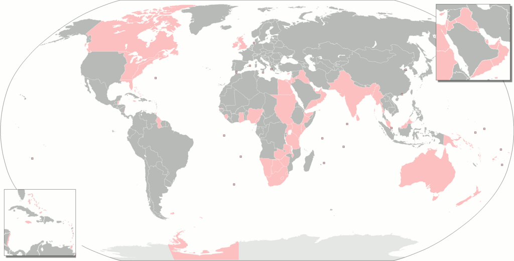
Deutsch: Gebiete, die zur einen oder anderen Zeit Teil des britischen Weltreiches waren.
English: The territories that were at one time or another part of the British Empire.
Français : Territoires ayant fait partie de l'Empire britanique.
Русский: Территории, когда-либо бывшие частью Британской империи.
Українська: Території, які колись були частиною Британської імперії. |
| Deiziad | |
| Mammenn | Labour an-unan |
| Aozer | Gd21091993 |
| Stummoù all |
The British Empire.png The British Empire (including Crown Dependencies, Crown Colonies-Overseas Territories, Protectorates, Military Administrations).png Map of British India.png British Empire Map (Chinese).svg The British Empire Anachronous.png forked on enwiki |
.png)
.svg)
Aotre-implijout
| Me, perc'henn war gwirioù an oberenn-mañ, a laka anezhi en domani foran. Talvezout a ra kement-mañ evit ar bed a-bezh. E broioù zo e c'hall kement-mañ bezañ dibosupl ent lezennel; mard emañ kont evel-se : Reiñ a ran aotre d'an holl da implijout an oberenn-mañ evit ober ne vern petra, hep tamm bevenn ebet estreget hini al lezenn. |
Istor ar restr
Klikañ war un deiziad/eur da welet ar restr evel ma oa da neuze.
| Deiziad/Eur | Munud | Mentoù | Implijer | Notenn | |
|---|---|---|---|---|---|
| red | 7 Du 2021 da 23:48 | | 2 754 × 1 398 (145 Kio) | Randomastwritter | somali galbeed |
| 31 Her 2021 da 00:51 |  | 2 754 × 1 398 (144 Kio) | Randomastwritter | juba | |
| 31 Her 2021 da 00:49 |  | 2 754 × 1 400 (526 Kio) | Randomastwritter | jubaland | |
| 3 C'hwe 2018 da 23:20 |  | 2 754 × 1 398 (144 Kio) | Maphobbyist | Upload | |
| 27 Gen 2018 da 10:42 |  | 2 754 × 1 398 (144 Kio) | Maphobbyist | Added Weihei, Heligoland, the Mosquito Coast, Afghanistan which were under some form of British rule. Colored Chatham Islands of New Zealand and the southeastern islands of Papua New Guinea in pink. | |
| 16 C'hwe 2013 da 07:45 |  | 2 753 × 1 400 (65 Kio) | JohnnyMrNinja | remove unused alpha, indexed colors and increased compression | |
| 2 Mae 2010 da 19:50 |  | 2 753 × 1 400 (477 Kio) | Gd21091993 | {{Information |Description={{fr|1=Toute les possessions qui on un jour fait partie de l'empire britanique}} |Source={{own}} |Author=Gd21091993 |Date=02/05/2010 |Permission= |other_versions= }} |
Implij ar restr
Implijout a ra an 3 pajenn da heul ar restr-mañ :
Implij hollek ar restr
Ober a ra ar wikioù da-heul gant ar restr-mañ :
- Implij war an.wikipedia.org
- Implij war bs.wikipedia.org
- Implij war da.wikipedia.org
- Implij war eo.wikipedia.org
- Implij war es.wikipedia.org
- Implij war eu.wikipedia.org
- Implij war fa.wikipedia.org
- Implij war fr.wikipedia.org
- Implij war gl.wikipedia.org
- Implij war hak.wikipedia.org
- Implij war hif.wikipedia.org
- Implij war hr.wikipedia.org
- Implij war hu.wikipedia.org
- Implij war hu.wiktionary.org
- Implij war is.wikipedia.org
- Implij war it.wikipedia.org
- Implij war ne.wikipedia.org
- Implij war nl.wikipedia.org
- Implij war ro.wikipedia.org
- Implij war ru.wiktionary.org
- Implij war sah.wikipedia.org
- Implij war sh.wikipedia.org
- Implij war xh.wikipedia.org