Restr:United Kingdom 1843.jpg

Restr orin (2 482 × 3 404 piksel, ment ar restr : 3,55 Mio, seurt MIME : image/jpeg)
![]()
| Tennet eo ar restr-mañ eus Wikimedia Commons ha gallout a ra bezañ implijet evit raktresoù all. Diskouezet eo deskrivadur he fajenn zeskrivañ amañ dindan. |
Diverradur
| Deskrivadur |
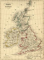
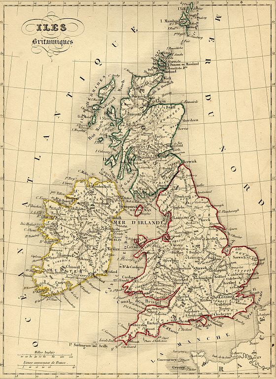
Français : Carte géographique ancienne du Royaume Uni (Angleterre, Galles, Ecosse) et de l'Irlande avec noms en français dressée par le géographe Alexandre Vuillemin en 1843 extraite de son “Atlas universel de géographie ancienne et moderne à l'usage des pensionnats”. Le titre original de cette carte est “Iles britanniques”.
Cet atlas était initialement monochrome mais son premier propriétaire a réhaussé manuellement en couleur les frontières ou limites administratives.
English: Map of United Kingdom (England, Wales, Scotland) and Ireland with french names made by Alexandre Vuillemin in 1843 extracted from his “Atlas universel de géographie ancienne et moderne à l'usage des pensionnats”. The map was originally monochrome but its first owner manually highlighted the national borders in colour. |
| Deiziad | |
| Mammenn | |
| Aozer | Alexandre Vuillemin (reproduit par histoirepostale.net) |
Aotre-implijout
This image is in the public domain because it is a mere mechanical scan or photocopy of a public domain original, or – from the available evidence – is so similar to such a scan or photocopy that no copyright protection can be expected to arise. The original itself is in the public domain for the following reason:
This tag is designed for use where there may be a need to assert that any enhancements (eg brightness, contrast, colour-matching, sharpening) are in themselves insufficiently creative to generate a new copyright. It can be used where it is unknown whether any enhancements have been made, as well as when the enhancements are clear but insufficient. For known raw unenhanced scans you can use an appropriate {{PD-old}} tag instead. For usage, see Commons:When to use the PD-scan tag.  | ||||
Istor ar restr
Klikañ war un deiziad/eur da welet ar restr evel ma oa da neuze.
| Deiziad/Eur | Munud | Mentoù | Implijer | Notenn | |
|---|---|---|---|---|---|
| red | 11 Du 2007 da 11:39 | | 2 482 × 3 404 (3,55 Mio) | Dlebouc | == Description == {{Information |Description= {{fr|Carte du Royaume Uni (Angleterre, Galles, Ecosse) avec noms en français dressée par le géographe Alexandre Vuillemin en 1843 extraite de son “Atlas universel de géographie ancienne et moderne à l'u |
Implij ar restr
Implijout a ra ar bajenn da heul ar restr-mañ :
Implij hollek ar restr
Ober a ra ar wikioù da-heul gant ar restr-mañ :
- Implij war ca.wikipedia.org
- Implij war en.wikipedia.org
- Implij war fi.wikipedia.org
- Implij war fr.wikipedia.org
- Implij war gcr.wikipedia.org
- Implij war ht.wikipedia.org
- Implij war la.wikipedia.org
- Implij war pcd.wikipedia.org
- Implij war pl.wikipedia.org