Restr:United Kingdom EU referendum 2016 area results 2-tone.svg

Ment rakwel PNG ar restr SVG : 405 × 599 piksel. pizhderioù all : 162 × 240 piksel | 324 × 480 piksel | 519 × 768 piksel | 692 × 1 024 piksel | 1 384 × 2 048 piksel | 871 × 1 289 piksel.
Restr orin (restr SVG file, pizhder 871 × 1 289 piksel, ment ar restr : 4,66 Mio)
![]()
| Tennet eo ar restr-mañ eus Wikimedia Commons ha gallout a ra bezañ implijet evit raktresoù all. Diskouezet eo deskrivadur he fajenn zeskrivañ amañ dindan. |
Diverradur
| Deskrivadur |
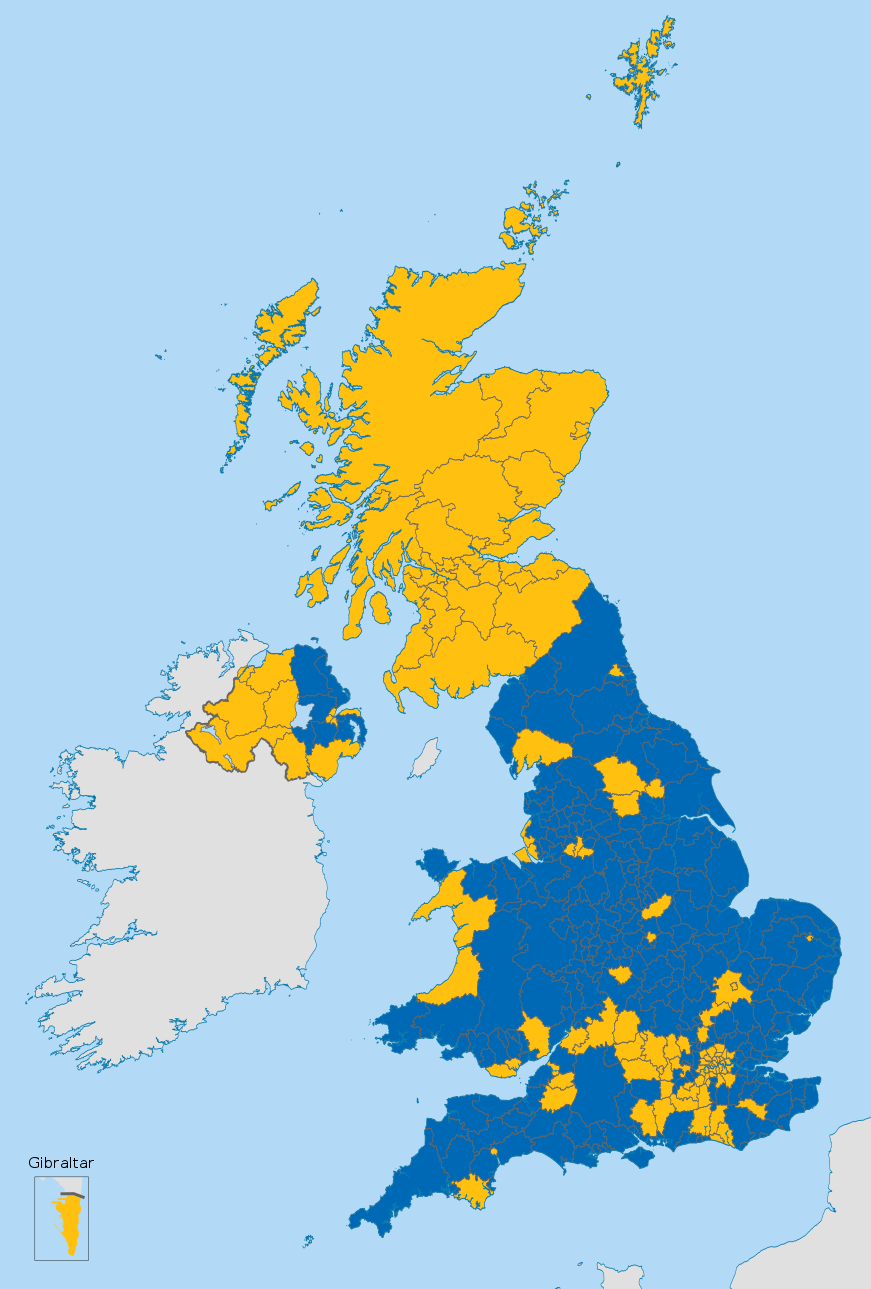
English (en): Map of the United Kingdom showing the voting areas for the European Union membership referendum, 2016.
Leave Remain
|
| Deiziad | |
| Mammenn |
This vector image includes elements that have been taken or adapted from this file: This vector image includes elements that have been taken or adapted from this file: This vector image includes elements that have been taken or adapted from this file: This vector image includes elements that have been taken or adapted from this file: This vector image includes elements that have been taken or adapted from this file: |
| Aozer |
Mirrorme22 Nilfanion: English and Scottish council areas TUBS: Welsh council areas Sting: Gibraltar |
| Stummoù all |
 |
| SVG genesis |
Aotre-implijout
Emañ ar restr-mañ dindan an aotre-implijout Creative Commons Deroadenn-Kenrannañ 3.0 Unported
- Gallout a rit :
- eskemm – eilañ, skignañ ha treuzkas an oberenn-mañ
- kemmañ – azasaat an oberenn-mañ
- diouzh ma heuilhit kement-mañ :
- deroadenn – Rankout a rit reiñ an titouroù perc'henniezh rekis diwar-benn an aozer, pourchas ul liamm war-zu an aotre-implijout ha merkañ hag-eñ ez eus bet graet kemmoù. Gallout a rit en ober en un doare reizh met hep lakaat da grediñ ez oc'h bet aprouet gantañ pe ez eo aprouet gantañ implij an oberenn-mañ.
- eskemmañ rik-ha-rik – Ma tegasit kemmoù, ma treuzfurmit pe ma savit un dra bennak diwar an oberenn-mañ e rankit skignañ an oberenn krouet ganeoc'h dindan an hevelep aotre-implijout pe un aotre-implijout kar-tost d'an hini orin.
Istor ar restr
Klikañ war un deiziad/eur da welet ar restr evel ma oa da neuze.
| Deiziad/Eur | Munud | Mentoù | Implijer | Notenn | |
|---|---|---|---|---|---|
| red | 25 Gou 2016 da 20:09 | | 871 × 1 289 (4,66 Mio) | Cranberry Products | fixed Horsham and Havant |
| 24 Mez 2016 da 19:06 |  | 871 × 1 289 (4,66 Mio) | Nilfanion | Reverted, dark boundary lines please - white is jarring | |
| 24 Mez 2016 da 19:04 |  | 871 × 1 289 (4,66 Mio) | EmmaCoop | Wrong upload | |
| 24 Mez 2016 da 17:54 |  | 871 × 1 289 (4,66 Mio) | EmmaCoop | Set boundaries to #fff | |
| 24 Mez 2016 da 09:08 |  | 871 × 1 289 (4,66 Mio) | Nilfanion | fix Carms | |
| 24 Mez 2016 da 07:42 |  | 871 × 1 289 (4,66 Mio) | Nilfanion | full results | |
| 24 Mez 2016 da 01:13 |  | 871 × 1 289 (4,66 Mio) | Nilfanion | =={{int:filedesc}}== {{Information |description={{en|1=Map of the United Kingdom showing the voting areas for the European Union membership referendum, 2016.}} |date=2016-02-20 |source={{AttribSVG|Scottish council areas 2011.svg|Nilfanion}}{{AttribSVG|... |
Implij ar restr
Implijout a ra ar bajenn da heul ar restr-mañ :
Implij hollek ar restr
Ober a ra ar wikioù da-heul gant ar restr-mañ :
- Implij war als.wikipedia.org
- Implij war an.wikipedia.org
- Implij war ast.wikipedia.org
- Implij war bat-smg.wikipedia.org
- Implij war ca.wikipedia.org
- Implij war ckb.wikipedia.org
- Implij war cy.wikipedia.org
- Implij war da.wikipedia.org
- Implij war de.wikipedia.org
- Implij war el.wikipedia.org
- Implij war eml.wikipedia.org
- Implij war en.wikipedia.org
- Referendums in the United Kingdom
- Political history of the United Kingdom (1979–present)
- 2016 United Kingdom European Union membership referendum
- Brexit
- European Union Referendum Act 2015
- Results of the 2016 United Kingdom European Union membership referendum
- Wikipedia:In the news/Candidates/June 2016
- Talk:2016 United Kingdom European Union membership referendum/Archive 2
- Template:UKEU2016Results
- Talk:2016 United Kingdom European Union membership referendum/Archive 3
- Aftermath of the 2016 United Kingdom European Union membership referendum
- United Kingdom membership of the European Union
- Implij war eo.wikipedia.org
- Implij war es.wikipedia.org
- Implij war et.wikipedia.org
- Implij war eu.wikipedia.org
- Implij war fi.wikipedia.org
- Implij war fr.wikipedia.org
- Implij war gl.wikipedia.org
- Implij war id.wikipedia.org
- Implij war it.wikipedia.org
- Implij war jv.wikipedia.org
- Implij war ko.wikipedia.org
Gwelet muioc'h eus implij hollek ar restr-mañ.