Restr:Volga German03.png

Ment ar rakweled-mañ : 576 × 600 piksel. pizhderioù all : 230 × 240 piksel | 626 × 652 piksel.
Restr orin (626 × 652 piksel, ment ar restr : 46 Kio, seurt MIME : image/png)
![]()
| Tennet eo ar restr-mañ eus Wikimedia Commons ha gallout a ra bezañ implijet evit raktresoù all. Diskouezet eo deskrivadur he fajenn zeskrivañ amañ dindan. |
Diverradur
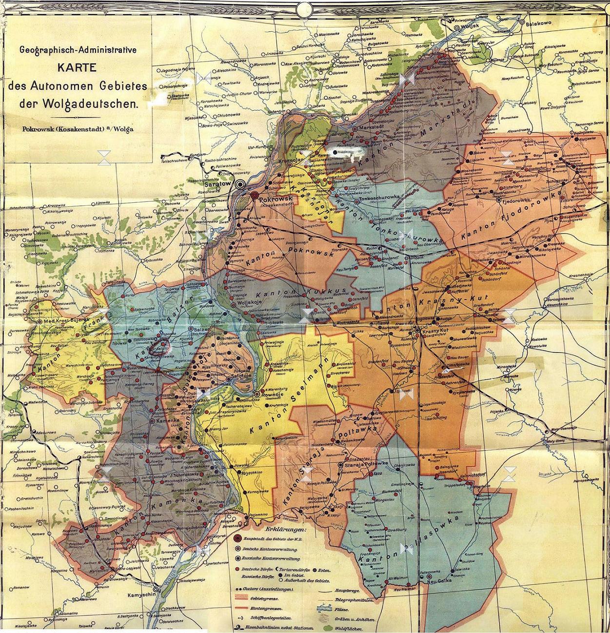
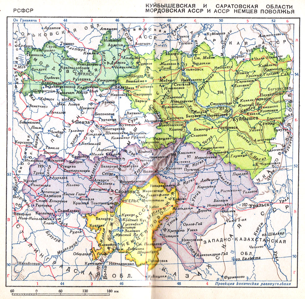
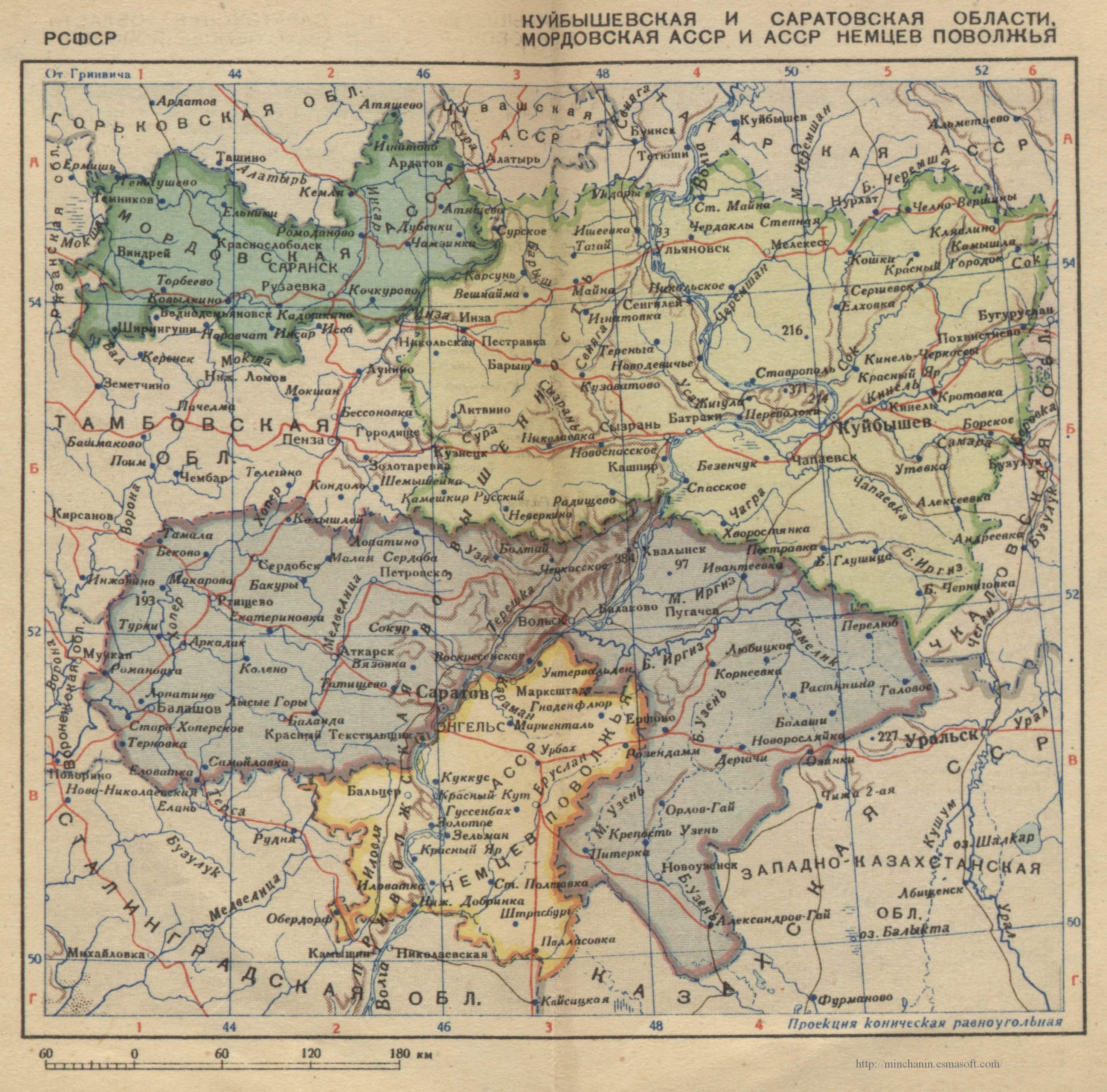
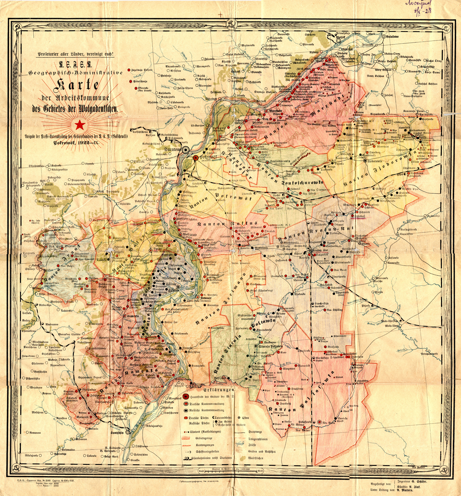
| Deskrivadur | This is an map of the former Volga German Autonomous Soviet Socialist Republic (Volga German ASSR) that existed from 1924 to 1941. It shows the location of major settlements, including the capital, Engels (Pokrovsk). |
| Deiziad | 29 Kerzu 2006 (original upload date) |
| Mammenn | Labour an-unan |
| Aozer | PANONIAN |
Source and license

|
This map has been uploaded by Electionworld from en.wikipedia.org to enable the |
historic map (self made by user:PANONIAN)
Aotre-implijout
| Me, perc'henn war gwirioù an oberenn-mañ, a laka anezhi en domani foran. Talvezout a ra kement-mañ evit ar bed a-bezh. E broioù zo e c'hall kement-mañ bezañ dibosupl ent lezennel; mard emañ kont evel-se : Reiñ a ran aotre d'an holl da implijout an oberenn-mañ evit ober ne vern petra, hep tamm bevenn ebet estreget hini al lezenn. |
References
- http://terkepek.adatbank.transindex.ro/kepek/netre/24.gif
- http://www.zum.de/whkmla/histatlas/russia/volgagermanassr2t.gif
- http://www.zum.de/whkmla/histatlas/russia/volgagermanassr2.gif
- http://cvgs.cu-portland.edu/images/map_vg_republic_index.jpg
- http://www.volgagermans.net/norka/images/Volga-German-ASSR-1928-1600px.jpg
- http://www.frank-kolb-russia.org/images/volga-german-assr.jpg
- http://www2.ku.edu/~germanic/LAKGD/Dinges/Dinges1.jpg
- http://images.ookaboo.com/photo/m/Volga_Oblasts_and_ASSRs_in_1940_m.jpg
- http://www.rusdeutsch.ru/image/history/Glava8/АССР%20немцев%20Поволжья%20в%201941%20г..jpg
- http://wolgadeutsche.ru/karten/ASSRdWD.jpg
- http://wolgadeutsche.net/lexikon/img/ASSRdWD.jpg
- http://wolgadeutsche.net/lexikon/img/Saratow_kraj_1934b.jpg
- http://wolgadeutsche.net/lexikon/img/ASSRdWD_1938.jpg
- http://s40.radikal.ru/i088/1001/12/652dcba6b7e8.jpg
- http://www.schuk.ru/1/maps/1935.jpg
- http://upload.wikimedia.org/wikipedia/de/7/7f/Wolgadeutsche_ASSR.jpg
- http://genze.webstolica.ru/_mod_files/ce_images/Volga/volgade_-_1923.jpg
- http://dic.academic.ru/pictures/wiki/files/86/Volga_Oblasts_and_ASSRs_in_1940.jpg
- http://minchanin.esmasoft.com/maps/ussr1939/maps/20.jpg
- http://upload.wikimedia.org/wikipedia/commons/8/8c/Volga_Oblasts_and_ASSRs_in_1940.jpg
- http://upload.wikimedia.org/wikipedia/commons/9/9e/Karta_AGW_1922.jpg
- http://upload.wikimedia.org/wikipedia/ru/2/2e/АССР_Немцев_Поволжья.png
Istor ar restr
Klikañ war un deiziad/eur da welet ar restr evel ma oa da neuze.
| Deiziad/Eur | Munud | Mentoù | Implijer | Notenn | |
|---|---|---|---|---|---|
| red | 15 Gou 2012 da 15:07 | | 626 × 652 (46 Kio) | PANONIAN | improved version |
| 29 Kzu 2006 da 13:11 |  | 523 × 524 (17 Kio) | Electionworld | {{ew|en|PANONIAN}} historic map (self made) {{PD-self}} Category:Maps of the history of Russia |
Implij ar restr
Implijout a ra ar bajenn da heul ar restr-mañ :
Implij hollek ar restr
Ober a ra ar wikioù da-heul gant ar restr-mañ :
- Implij war az.wikipedia.org
- Implij war ba.wikipedia.org
- Implij war be-tarask.wikipedia.org
- Implij war be.wikipedia.org
- Implij war bg.wikipedia.org
- Implij war ca.wikipedia.org
- Implij war cs.wikipedia.org
- Implij war da.wikipedia.org
- Implij war de.wikipedia.org
- Implij war en.wikipedia.org
- Implij war eo.wikipedia.org
- Implij war es.wikipedia.org
- Implij war fa.wikipedia.org
- Implij war fi.wikipedia.org
- Implij war fr.wikipedia.org
- Implij war gl.wikipedia.org
- Implij war hsb.wikipedia.org
- Implij war hu.wikipedia.org
- Implij war it.wikipedia.org
- Implij war ja.wikipedia.org
- Implij war ko.wikipedia.org
- Implij war lt.wikipedia.org
- Implij war pt.wikipedia.org
- Implij war ro.wikipedia.org
- Implij war ru.wikipedia.org
- Implij war sh.wikipedia.org
- Implij war sr.wikipedia.org
- Implij war tr.wikipedia.org
- Implij war uk.wikipedia.org
- Implij war zh.wikipedia.org