Restr:WW2 Holocaust Europe N-E map-fr.svg

Ment rakwel PNG ar restr SVG : 719 × 600 piksel. pizhderioù all : 288 × 240 piksel | 575 × 480 piksel | 921 × 768 piksel | 1 227 × 1 024 piksel | 2 455 × 2 048 piksel | 1 268 × 1 058 piksel.
Restr orin (restr SVG file, pizhder 1 268 × 1 058 piksel, ment ar restr : 277 Kio)
![]()
| Tennet eo ar restr-mañ eus Wikimedia Commons ha gallout a ra bezañ implijet evit raktresoù all. Diskouezet eo deskrivadur he fajenn zeskrivañ amañ dindan. |
Diverradur
| Deskrivadur |
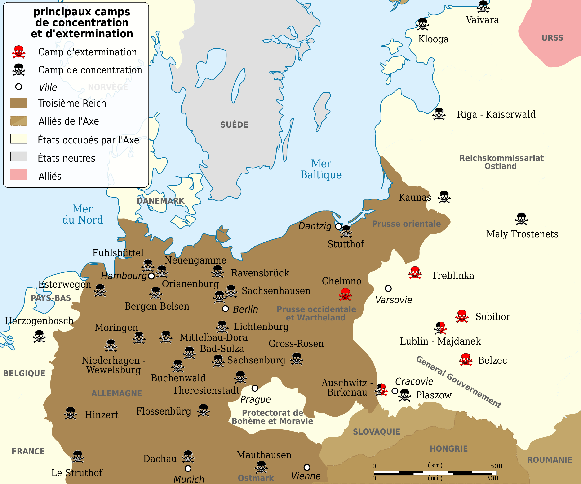
Deutsch: Vernichtungs- und Konzentrationslager während des 2. Weltkrieges, Grenzen von 1943. English: Map of the Holocaust in Europe during World War II, 1939-1945. This map shows all German extermination camps (or death camps), most major concentration camps, labor camps, prison camps, ghettos, major deportation routes and major massacre sites. Notes: 1. Extermination camps were dedicated death camps, but all camps and ghettos took a toll of many, many lives. 2. Concentration camps include labor camps, prison camps & transit camps. 3. Not all camps & ghettos are shown. 4. Borders are at the height of Axis domination (1942). 5. Some regions have German designations (e.g. "Ostland"), with the present country name denoted in uppercase letters in parenthesis below the German designation (e.g. "(AUSTRIA)"). 6. Present (2007) borders are dotted. Español: Campos de concentración y exterminio nazis durante la II Guerra Mundial, fronteras de 1943. Français : Principaux camps de concentrations et d'extermination pendant la deuxième guerre mondiale. Frontières de 1943. Kurdî: Topkırın û kûştîn kamp â Nazi â Alamanê. Polski: Niemieckie obozy koncentracyjne w europie, ze względu na to że obozy zmieniały swe funkcje nie są one rozróżnione na mapie, Granice państw stan z 1943 r. Português: Campos de concentração e extermínio nazistas durante a II Guerra Mundial, fronteiras de 1943. Türkçe: Önemli, Alman Nazi toplama ve yok etme kampları. 1943 sınırları. |
||||
| Deiziad | (UTC) | ||||
| Mammenn | |||||
| Aozer | |||||
| Stummoù all |
[]
| ||||
| Deroadenn (required by the license) | © Sémhur / Wikimedia Commons / | ||||
| SVG | W3C-validity not checked.
|
||||
| Graphic Lab |


.png)


.png)


Aotre-implijout
Evel perc'henn eus ar gwirioù oberour, e embannan an oberenn-mañ dindan an aotreoù-implijout da-heul :
| Copyleft : Frank eo an oberenn-mañ ; gallout a rit addasparzhañ pe/ha kemmañ anezhi hervez an Aotre-implijout Arz Frank. Kavout a reot ur skouerenn eus an aotre-implijout-mañ e lec'hienn Copyleft Attitude hag e lec'hiennoù all ivez. |
This file is licensed under the Creative Commons Attribution-Share Alike 4.0 International, 3.0 Unported, 2.5 Generic, 2.0 Generic and 1.0 Generic license.
- Gallout a rit :
- eskemm – eilañ, skignañ ha treuzkas an oberenn-mañ
- kemmañ – azasaat an oberenn-mañ
- diouzh ma heuilhit kement-mañ :
- deroadenn – Rankout a rit reiñ an titouroù perc'henniezh rekis diwar-benn an aozer, pourchas ul liamm war-zu an aotre-implijout ha merkañ hag-eñ ez eus bet graet kemmoù. Gallout a rit en ober en un doare reizh met hep lakaat da grediñ ez oc'h bet aprouet gantañ pe ez eo aprouet gantañ implij an oberenn-mañ.
- eskemmañ rik-ha-rik – Ma tegasit kemmoù, ma treuzfurmit pe ma savit un dra bennak diwar an oberenn-mañ e rankit skignañ an oberenn krouet ganeoc'h dindan an hevelep aotre-implijout pe un aotre-implijout kar-tost d'an hini orin.
Gallout a rit diuzañ an aotre-implijout a fell deoc'h.
Marilh orin ar pellgargadurioù
This image is a derivative work of the following images:
- File:Konzentrazionslager.png licensed with GFDL, GFDL/fr
- File:WW2_Holocaust_Europe_map-fr.svg licensed with Cc-by-3.0, Cc-by-3.0/fr
- 2009-05-11T16:52:07Z Sémhur 1310x1090 (607330 Bytes) {{Information |Description=Map of the Holocaust in Europe during World War II, 1939-1945. This map shows all extermination camps (or ''death camps''), most major concentration camps, labor camps, prison camps, ghettos, major
Uploaded with derivativeFX
Istor ar restr
Klikañ war un deiziad/eur da welet ar restr evel ma oa da neuze.
| Deiziad/Eur | Munud | Mentoù | Implijer | Notenn | |
|---|---|---|---|---|---|
| red | 11 Mae 2009 da 17:02 | | 1 268 × 1 058 (277 Kio) | Sémhur | {{Information |Description={{pt|Campos de concentração e extermínio nazistas durante a II Guerra Mundial, fronteiras de 1943}} {{es|Campos de concentración y exterminio nazis durante la II Guerra Mundial, fronteras de 1943}} {{fr|Camps de concentratio |
Implij ar restr
Implijout a ra ar bajenn da heul ar restr-mañ :
Implij hollek ar restr
Ober a ra ar wikioù da-heul gant ar restr-mañ :
- Implij war fi.wikipedia.org
- Implij war fr.wikipedia.org
- Implij war fr.wikiversity.org
- Implij war sv.wikipedia.org