Chaumont-Gistoux
Chaumont-Gistoux (walloneg : Tchåmont-Djistou) zo ur gumun e Belgia e Proviñs Brabant Wallonia.
-
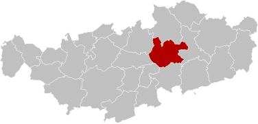 Lec'hiadur
 -
 Banniel
 -


Chaumont-Gistoux

| Anv annezidi | Chaumontois |
|---|---|
| Yezh ofisiel | galleg |
| Stad | Belgia |
| Kêr-benn | Chaumont-Gistoux |
| E tiriad | Arondisamant Nivelles |
| Gwerzhid-eur | UTC+01:00 |
| Lec'hiadur | Brabantian Ardennes |
| Daveennoù douaroniel | 50°41′2″N 4°41′41″E |
| Post dalc'het gant penn ar gouarnamant | Mayor of Chaumont-Gistoux |
| Penn an aotrouniezh | Luc Decorte |
| Furm lezennel | Kêrioù ha kumunioù |
| Contains settlement | Dion-le-Val, Corroy-le-Grand, Longueville |
| A zo stok ouzh | Grez-Doiceau, Walhain |
| Kod-post | 1325 |
| Niverenn bellgomz | +32 10 68 72 11 |
| Postel | mailto:info@chaumont-gistoux.be |
| Lec'hienn ofisiel | https://www.chaumont-gistoux.be/ |
| Banniel (deskrivadur) | flag of Chaumont-Gistoux |
| Ardamezioù | Q42170249 |
| Roll monumantoù | list of protected heritage sites in Chaumont-Gistoux |
| Kod pellgomz an takad | 010 |
| Rummad evit ar c'hartennoù | Category:Maps of Chaumont-Gistoux |

Douaroniezh
kemmañ- Gorread : 48,33 km²
- Poblañs (2022) : 11 685 a dud
- Stankter : 242 den/km²