Restr:Carte Guerre de Sept Ans Europe.PNG
Restr orin (884 × 643 piksel, ment ar restr : 77 Kio, seurt MIME : image/png)
![]()
| Tennet eo ar restr-mañ eus Wikimedia Commons ha gallout a ra bezañ implijet evit raktresoù all. Diskouezet eo deskrivadur he fajenn zeskrivañ amañ dindan. |
Incorrect Information
- After the Russian-Swedisch war of 1741–1743 Finnland was russian in the East, up to the river Kymijoki, and Swedish in the western part. --El bes (talk) 21:02, 10 August 2008 (UTC)
An even bigger error here is that the UK, formed in 1707, is listed as England. Also, Ireland didn't join the Union until 1801, and at the time was still a kingdom in its own right.
Poland should be shown as the Polish-Lithuanian Commonwealth.
Austro-Ottoman borders shown here are actually from 1718-1739 period, between Treaty of Požarevac and Treaty of Belgrade

|
This historical map image could be re-created using vector graphics as an SVG file. This has several advantages; see Commons:Media for cleanup for more information. If an SVG form of this image is available, please upload it and afterwards replace this template with
{{vector version available|new image name}}.
It is recommended to name the SVG file “Carte Guerre de Sept Ans Europe.svg”—then the template Vector version available (or Vva) does not need the new image name parameter. |
Diverradur
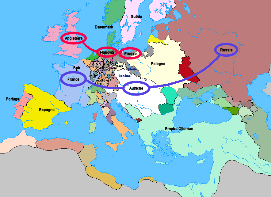
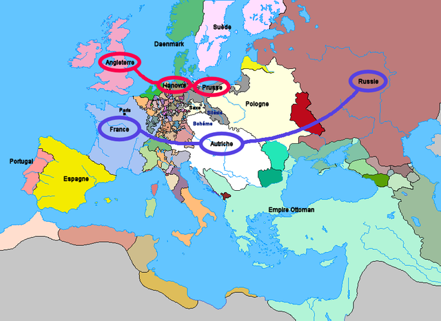
Carte de l'Europe et des alliances à la veille de la guerre de Sept Ans (1757)
Aotre-implijout
Upload: Wordelle
| Me, perc'henn war gwirioù an oberenn-mañ, a laka anezhi en domani foran. Talvezout a ra kement-mañ evit ar bed a-bezh. E broioù zo e c'hall kement-mañ bezañ dibosupl ent lezennel; mard emañ kont evel-se : Reiñ a ran aotre d'an holl da implijout an oberenn-mañ evit ober ne vern petra, hep tamm bevenn ebet estreget hini al lezenn. |
La source n’a pas pu être reconnue automatiquement. « Travail personnel » supposé (étant donné la revendication de droit d’auteur).
Istor ar restr
Klikañ war un deiziad/eur da welet ar restr evel ma oa da neuze.
| Deiziad/Eur | Munud | Mentoù | Implijer | Notenn | |
|---|---|---|---|---|---|
| red | 1 Gen 2012 da 21:25 | | 884 × 643 (77 Kio) | Artemis Dread | Republic of Ragusa |
| 24 Kzu 2011 da 22:19 |  | 884 × 643 (77 Kio) | Artemis Dread | Prince-Bishopric of Montenegro | |
| 18 Gwe 2011 da 10:58 |  | 884 × 643 (77 Kio) | Artemis Dread | Kingdom of Imereti and Kingdom of Kartli-Kakheti, minor changes | |
| 17 Gwe 2011 da 14:31 |  | 884 × 643 (76 Kio) | Artemis Dread | Finland | |
| 17 Gwe 2011 da 13:15 |  | 884 × 643 (76 Kio) | Artemis Dread | minor changes | |
| 17 Gwe 2011 da 12:17 |  | 884 × 643 (76 Kio) | Artemis Dread | Duchy of Courland and Semigallia | |
| 17 Gwe 2011 da 11:13 |  | 884 × 643 (76 Kio) | Artemis Dread | Cossack Hetmanate | |
| 17 Gwe 2011 da 10:36 |  | 884 × 643 (76 Kio) | Artemis Dread | vassals of the Ottoman Empire | |
| 18 Her 2006 da 09:30 |  | 884 × 643 (72 Kio) | Wordelle | Carte de l'Europe et des alliances à la veille de la guerre de Sept Ans (1757) |
Implij ar restr
Implijout a ra ar bajenn da heul ar restr-mañ :
Implij hollek ar restr
Ober a ra ar wikioù da-heul gant ar restr-mañ :
- Implij war af.wikipedia.org
- Implij war ar.wikipedia.org
- Implij war az.wikipedia.org
- Implij war bg.wikipedia.org
- Implij war ca.wikipedia.org
- Implij war cs.wikipedia.org
- Implij war de.wikipedia.org
- Implij war el.wikipedia.org
- Implij war en.wikipedia.org
- Military history of the Russian Empire
- Diplomatic Revolution
- Portal:Russia/Selected anniversaries
- Portal:Russia/Selected anniversaries/May
- Stately quadrille
- Wenzel Anton, Prince of Kaunitz-Rietberg
- History of the foreign relations of the United Kingdom
- User:Rjensen/International relations 1648-1814
- User:Falcaorib
- Implij war et.wikipedia.org
- Implij war eu.wikipedia.org
- Implij war fr.wikipedia.org
- Implij war fr.wikiversity.org
- Implij war he.wikipedia.org
- Implij war hu.wikipedia.org
- Implij war id.wikipedia.org
- Implij war it.wikipedia.org
- Implij war ja.wikipedia.org
- Implij war la.wikipedia.org
- Implij war lv.wikipedia.org
- Implij war ms.wikipedia.org
- Implij war nl.wikipedia.org
- Implij war nn.wikipedia.org
- Implij war no.wikipedia.org
- Implij war ro.wikipedia.org
- Implij war ru.wikipedia.org
- Implij war sh.wikipedia.org
- Implij war sr.wikipedia.org
- Implij war sv.wikipedia.org
- Implij war sw.wikipedia.org
- Implij war th.wikipedia.org
- Implij war tr.wikipedia.org
- Implij war uk.wikipedia.org
Gwelet muioc'h eus implij hollek ar restr-mañ.