Restr:England-878ad.jpg

Ment ar rakweled-mañ : 471 × 599 piksel. pizhderioù all : 189 × 240 piksel | 377 × 480 piksel | 735 × 935 piksel.
Restr orin (735 × 935 piksel, ment ar restr : 127 Kio, seurt MIME : image/jpeg)
![]()
| Tennet eo ar restr-mañ eus Wikimedia Commons ha gallout a ra bezañ implijet evit raktresoù all. Diskouezet eo deskrivadur he fajenn zeskrivañ amañ dindan. |

|
This map has been uploaded by Electionworld from en.wikipedia.org to enable the |
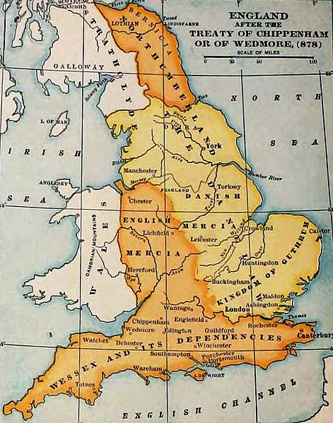
England and Wales at the time of the Treaty of Chippenham (AD 878). From the Atlas of European History, Earle W Dowe (d. 1946), G Bell and Sons, London, 1910
[]
-
 Cymraeg
 -
 Deutsch
 -
 English
 -
 English
 -
 English
 -
 español
 -
 français
 -
 Nederlands
 -
 polski
 -
 magyar


.svg)


|
The author died in 1946, so this work is in the public domain in its country of origin and other countries and areas where the copyright term is the author's life plus 75 years or fewer. This work is in the public domain in the United States because it was published (or registered with the U.S. Copyright Office) before January 1, 1929. | |
| Rummet eo bet ar restr-mañ e-touez ar restroù hep strishadurioù implij anavezet evit ar pezh a sell ouzh ar gwirioù aozer, ha kement-se evit an holl wirioù kar ha stag. | |
Istor ar restr
Klikañ war un deiziad/eur da welet ar restr evel ma oa da neuze.
| Deiziad/Eur | Munud | Mentoù | Implijer | Notenn | |
|---|---|---|---|---|---|
| red | 7 Du 2011 da 19:27 | | 735 × 935 (127 Kio) | Hel-hama | same source, better version of the image |
| 29 Kzu 2006 da 15:49 |  | 693 × 879 (79 Kio) | Electionworld | {{ew|en|Adamsan}} England and Wales at the time of the Treaty of Chippenham (AD 878). From the Atlas of European History, Earle W Dowe, G Bell and Sons, London, 1910 {{PD-US}} |
Implij ar restr
Implijout a ra ar bajenn da heul ar restr-mañ :
Implij hollek ar restr
Ober a ra ar wikioù da-heul gant ar restr-mañ :
- Implij war ar.wikipedia.org
- Implij war cs.wikipedia.org
- Implij war en.wikipedia.org
- Talk:Sub-Roman Britain
- Portal:Denmark/Selected article/2006 archive
- Portal:Denmark/Selected article/Week 20, 2006
- Portal:Denmark/Selected article/2007 archive
- Portal:Denmark/Selected article/Week 4, 2007
- Portal:Denmark/Selected article/Week 5, 2007
- Portal:Denmark/Selected article/Week 45, 2007
- Portal:Denmark/Selected article/Week 46, 2007
- Portal:Denmark/Selected article/2008 archive
- Portal:Denmark/Selected article/Week 3, 2008
- User:Amitchell125/danelaw
- Implij war eo.wikipedia.org
- Implij war fy.wikipedia.org
- Implij war hu.wikipedia.org
- Implij war id.wikipedia.org
- Implij war is.wikipedia.org
- Implij war it.wikipedia.org
- Implij war ja.wikipedia.org
- Implij war pt.wikipedia.org
- Implij war sh.wikipedia.org
- Implij war simple.wikipedia.org
- Implij war sk.wikipedia.org
- Implij war th.wikipedia.org
- Implij war uk.wikipedia.org
- Implij war zh.wikipedia.org