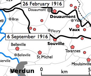
Restr:Fort Douaumont location map 300px.jpg
Fort_Douaumont_location_map_300px.jpg (300 × 250 piksel, ment ar restr : 53 Kio, seurt MIME : image/jpeg)
Istor ar restr
Klikañ war un deiziad/eur da welet ar restr evel ma oa da neuze.
| Deiziad/Eur | Munud | Mentoù | Implijer | Notenn | |
|---|---|---|---|---|---|
| red | 10 Gen 2010 da 16:27 |  | 300 × 250 (53 Kio) | Rcbutcher | {{Information |Description=Basic 300-pixel thumbnail map showing location of Fort Doumont in relation to Verdun and the other forts north and northeast of Verdun. The lines of advance of German forces as at 26 February and 6 Septemb |
Implij ar restr
Implijout a ra ar bajenn da heul ar restr-mañ :
Implij hollek ar restr
Ober a ra ar wikioù da-heul gant ar restr-mañ :
- Implij war ca.wikipedia.org
- Implij war en.wikipedia.org
- Implij war he.wikipedia.org
- Implij war tr.wikipedia.org
- Implij war zh.wikipedia.org


