Restr:The Mali Empire.jpg

Restr orin (3 000 × 2 250 piksel, ment ar restr : 3,07 Mio, seurt MIME : image/jpeg)
![]()
| Tennet eo ar restr-mañ eus Wikimedia Commons ha gallout a ra bezañ implijet evit raktresoù all. Diskouezet eo deskrivadur he fajenn zeskrivañ amañ dindan. |


Diverradur
| Deskrivadur |
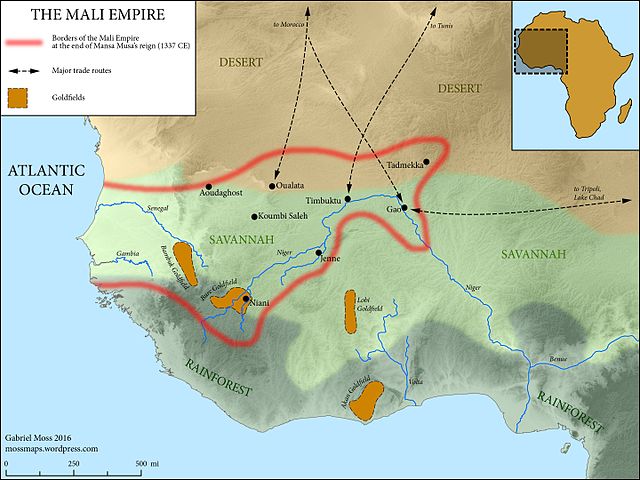
English: The Medieval Mali Empire at the end of Mansa Musa's reign (1337 CE)
Map Sources: Physical elevation representation comes from public-domain SRTM data. Coastlines follow the Barrington Atlas of the Ancient World (Princeton University Press, 2000)--while Mali hardly falls within the time period covered by this atlas, these coastlines omit major harbor construction in the modern period, and are accurate at the scale of the map. Rivers adapted from ESRI user contributions, or traced from satellite imagery. Ecological zones based on "A New Map of Standardized Terrestrial Ecosystems of Africa" (Association of American Geographers, 2013). Historical data drawn from Robert Collins and James Burns, "A History of Sub-Saharan Africa" (Cambridge University Press, 2007) (see esp. p. 86). Adapted and expanded based on lecture materials from Dr. Lisa Lindsay at the University of North Carolina-Chapel Hill, and from this map by wikimedia user Aa77zz: https://commons.wikimedia.org/wiki/File:Trans-Saharan_routes_early.svg |
| Deiziad | |
| Mammenn | Labour an-unan |
| Aozer | Gabriel Moss |
Aotre-implijout
- Gallout a rit :
- eskemm – eilañ, skignañ ha treuzkas an oberenn-mañ
- kemmañ – azasaat an oberenn-mañ
- diouzh ma heuilhit kement-mañ :
- deroadenn – Rankout a rit reiñ an titouroù perc'henniezh rekis diwar-benn an aozer, pourchas ul liamm war-zu an aotre-implijout ha merkañ hag-eñ ez eus bet graet kemmoù. Gallout a rit en ober en un doare reizh met hep lakaat da grediñ ez oc'h bet aprouet gantañ pe ez eo aprouet gantañ implij an oberenn-mañ.
- eskemmañ rik-ha-rik – Ma tegasit kemmoù, ma treuzfurmit pe ma savit un dra bennak diwar an oberenn-mañ e rankit skignañ an oberenn krouet ganeoc'h dindan an hevelep aotre-implijout pe un aotre-implijout kar-tost d'an hini orin.
Istor ar restr
Klikañ war un deiziad/eur da welet ar restr evel ma oa da neuze.
| Deiziad/Eur | Munud | Mentoù | Implijer | Notenn | |
|---|---|---|---|---|---|
| red | 13 Mez 2016 da 20:14 | | 3 000 × 2 250 (3,07 Mio) | Mossmaps | User created page with UploadWizard |
Implij ar restr
Implijout a ra ar bajenn da heul ar restr-mañ :
Implij hollek ar restr
Ober a ra ar wikioù da-heul gant ar restr-mañ :
- Implij war ar.wikipedia.org
- Implij war arz.wikipedia.org
- Implij war azb.wikipedia.org
- Implij war az.wikipedia.org
- Implij war ba.wikipedia.org
- Implij war bg.wikipedia.org
- Implij war en.wikipedia.org
- Implij war fi.wikipedia.org
- Implij war fr.wikipedia.org
- Implij war gl.wikipedia.org
- Implij war gpe.wikipedia.org
- Implij war ha.wikipedia.org
- Implij war he.wikipedia.org
- Implij war hi.wikipedia.org
- Implij war hy.wikipedia.org
- Implij war hyw.wikipedia.org
- Implij war it.wikipedia.org
- Implij war ja.wikipedia.org
- Implij war ky.wikipedia.org
- Implij war la.wikipedia.org
- Implij war lfn.wikipedia.org
- Implij war pt.wikipedia.org
- Implij war ru.wikipedia.org
- Implij war rw.wikipedia.org
- Implij war simple.wikipedia.org
- Implij war sl.wikipedia.org
- Implij war te.wikipedia.org
- Implij war tr.wikipedia.org
- Implij war uk.wikipedia.org
- Implij war vi.wikipedia.org
Gwelet muioc'h eus implij hollek ar restr-mañ.